SHOULD I TRUST THAT LEVEE?
J.
David Rogers, Ph.D., P.E., R.G., C.E.G.
Karl F. Hasselmann Chair in Geological Engineering
Department of Geological Sciences & Engineering
Missouri University of Science & Technology
129 McNutt Hall, 1400 N. Bishop Ave.
Rolla, MO 65409-0230
We’ve
all been there; glued to our TV sets watching the roving reporter in their
raincoat, standing by some levee that’s flooded in the past, asking: Will it happen again?
Each time it begins to rain with intensity it
seems the media begins using roving reporters to broadcast “flood watch” segments. We all know the spots, usually near levees or
bridges, where flooding has occurred in the past. Along the
WHAT ARE LEVEES
?
Rivers naturally prone to peak flood flows during
spring runoff develop natural overflow levees, deposited when the low flow
channel overtops its channel (see Figure 1).
Natural flow levees are typically comprised of more coarse grained
sediment, like sand, while the flood plain (Figure 2) is usually covered in
extremely fine silt. 75% of all the
sediment deposited upon the continent is overbank
silt, deposited upon well-defined flood plains.
Unfortunately, we have concentrated much of our societal
infrastructure upon these flood plains, and have thereby placed such property
in peril anytime the rivers begin to reach flood stage. In their natural state rivers tend to flow onto
their respective flood plains during peak runoff periods, generally during
the late spring months in
HOW ARE LEVEES DESIGNED
? In the 19th Century most towns were sited next
to the major rivers so that river-born commerce could access the community.
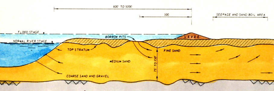
Levees, or dikes comprised of earth, were soon
built upon the river’s natural overflow levees as a means to provide protection
from flood flows (Figure 2). In the
Local reclamation districts and the Army Corps have since
joined forces to gradually heighten and extend great systems of levees along
those rivers normally prone to flooding, taking thousands of acres of flood
plain lowlands and “reclaiming” them for agriculture. Major sequences of Federal-aided levee construction
occurred in funding "sequences," in the 1930's and again, in the
late 1950's thru early 60's, providing the system of levees we see today. Following the disastrous 1927 and 1937 floods
along the lower CAN LEVEES BE DEPENDED
UPON FOR FLOOD CONTROL ? Being added onto every few decades, levees are
not engineered with the same precision, care, cost and engineering as other
hydraulic structures, such as dams. In
addition, levees extend for countless miles along major river channels, traversing
a heterogeneous assemblage of foundation conditions: crossing old channels,
sloughs, and oxbows perturbing any flood plain. The only constant of levees
is the inconsistency of their foundations. Because borrow pits and gravel quarries are
generally situated next to levees, a situation arises where seepage pressures
are introduced into the underlying flood plain
beneath the levee, and the duration of flooding dictates how long and
how far elevated seepage pressures will percolate beneath such embankments.
This situation is sketched in Figures 3, 4 and 5.
It only takes one break at a single discrete point to
flood the lowland protected by an entire system of levees. Given the variability of the levee foundations,
seepage-induced breaks are inevitable, especially in areas subject to localized
fluctuations of the water table, such as occurs when agricultural irrigation
practices change, or fields are left fallow (without summertime watering).
In the delta area the underlying soils are also consolidating each
year, causing differential settlement of the levees they support.
Longer duration floods tend to spawn greater hazard to
levees than short-term peak flows, as the longer the waterside of the levees
is inundated, the further flood-induced seepage can travel, beneath the levee,
and increases the possibility of destructive boils being formed on the landside
of the levee. It is for this reason that reclamation districts, responsible
for levee maintenance, employ crest patrols during flood stage, to continuously
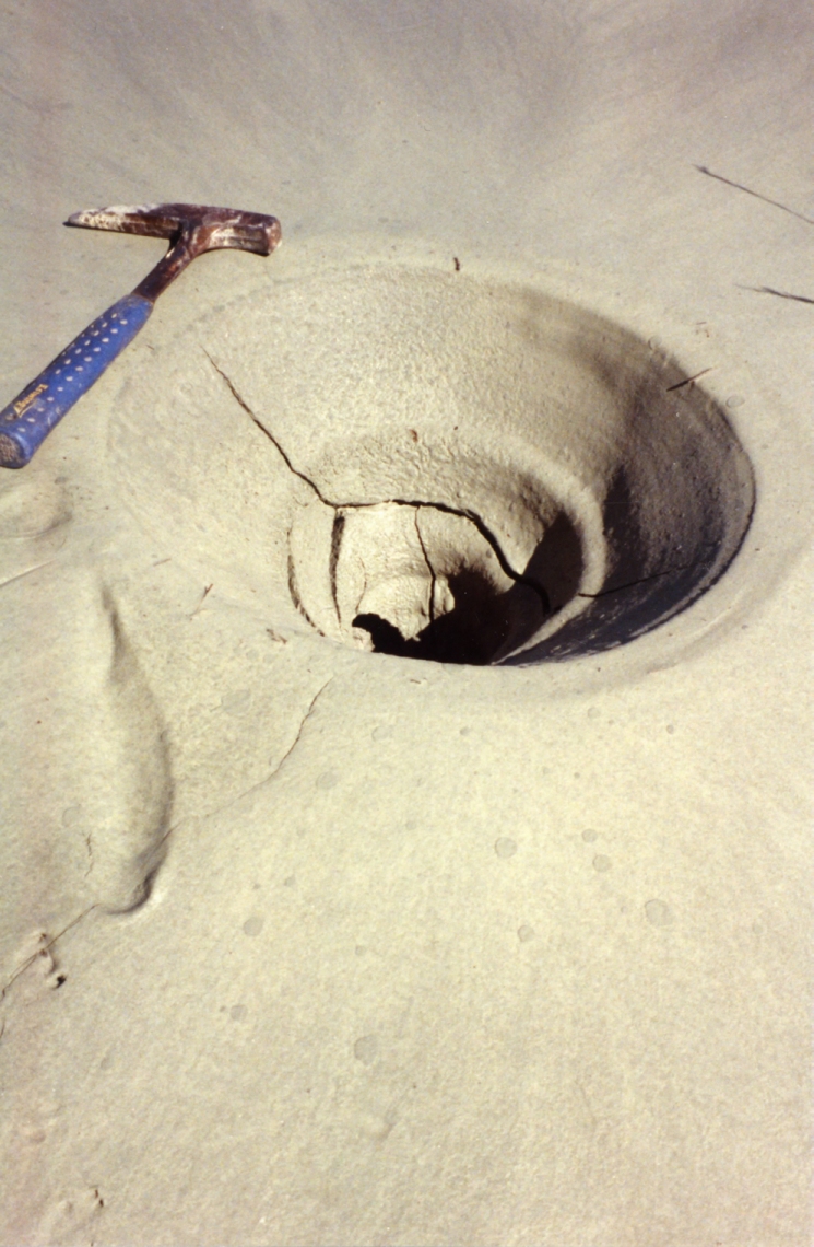
inspect the landside toe of the levees for onerous levels of seepage. Such patrols have limited ability to make immediate
response, that usually consisting or placing sandbag walls around boils to
increase confining (hydrostatic) pressure at the exit (boil) point (Figure
4). Judicious placement of sandbags around boils
can dispel disaster, but not in every circumstance (Figure 5).
In a growing number of
cases studied by the Corps of Engineers, short-term, semi-explosive decay of levee integrity
has occurred, due to excessive straining of any foundation materials subject
to an upward-flowing seepage front, usually emanating from an old, buried
channel (lying beneath the levee). In
these cases, routine patrols with sandbags may be insufficient to dispel a
disaster. WHAT DOES THE FUTURE
HOLD ? Flooding is a natural peril that has been exacerbated
by wholesale development in In order to safeguard development on the flood plains,
we have attempted to control nature through catchment
of debris and safe conveyance of the flood waters to the ocean. This flood infrastructure requires extensive
maintenance in order to be effective. Any
number of factors could combine to create inadequate flood control at any
given time. Some of these factors include:
back-to-back storms, warm rainfall on snow pack; inadequate design storage
of reservoirs or channels due to lack of siltation
maintenance; volcanic erruptions clogging channels;
or the failure of any particular piece of the “chain of flow”. As our flood infrastructure ages, we can expect
more failures of the system to occur. For
instance, the loss of the radial gate on Folsom Dam in July 1995 was a failure
mode never seen before, tied to the age of the structure (built in 1955).
It is difficult to assess risk for causes of occurrence which have
yet to have ever occurred, but we can expect more. The passage of the National Flood Protection Act of 1968
created a federally-funded system of insurance for property owners living
in defined flood plains, and set rates according to relative risk of inundation.
As the levees held and insurance became universally available, these
agricultural tracts have slowly been giving over to urbanization, putting
more people at flood risk each year. Still, floods are the only natural peril currently
under a federally-mandated system of insurance, adjudicated by the Federal
Emergency Management Agency (FEMA). A
problem which continues to plague the NFIP is updating flood plains with increasing
development, adjusting rates with the changing risk of inundation, and determining
regional value indexes tied to inflation and cost of repair, which vary considerably
depending on the area. Levee or not, floods, like other natural perils, will
always be with us. J. David Rogers is the Karl F. Hasselmann
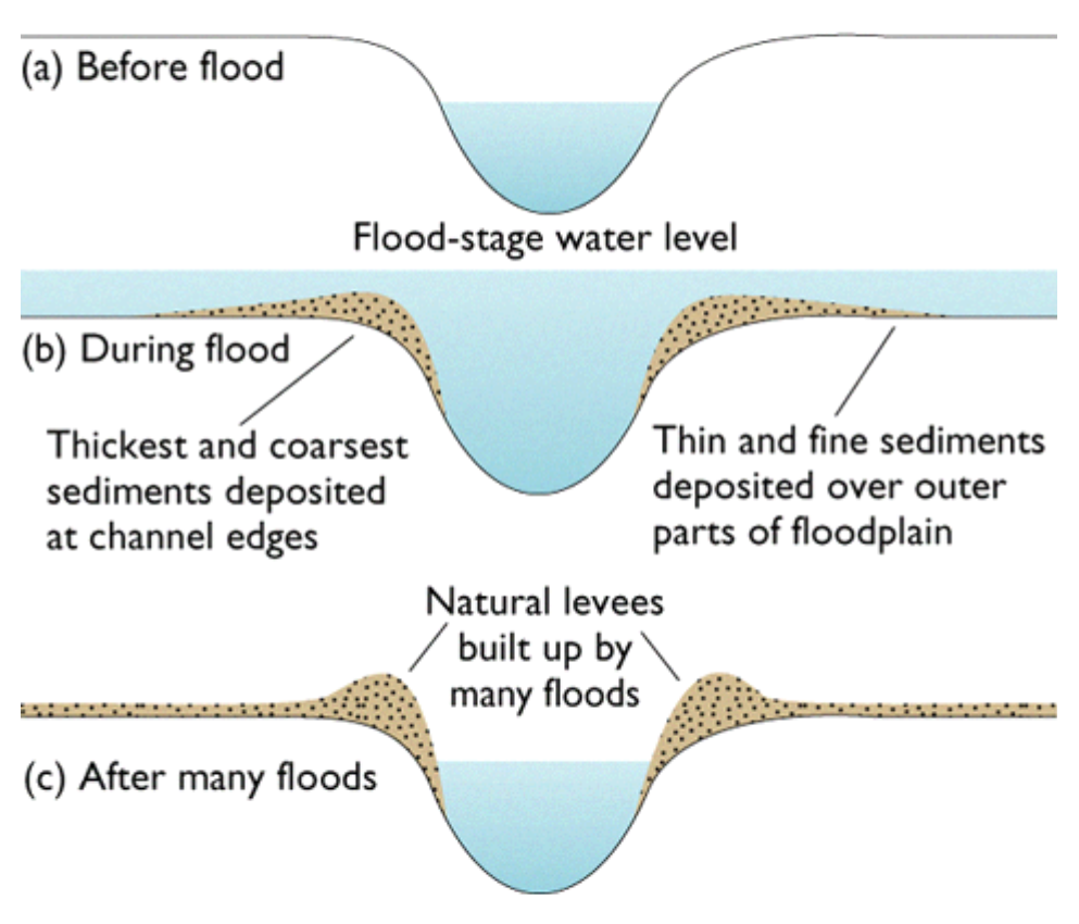

Figure 2 - Maximal loading
of a flood protection levee in Mississippi during the flood of 1973
Note school bus for scale and the seepage along the landside toe of the
embankment.
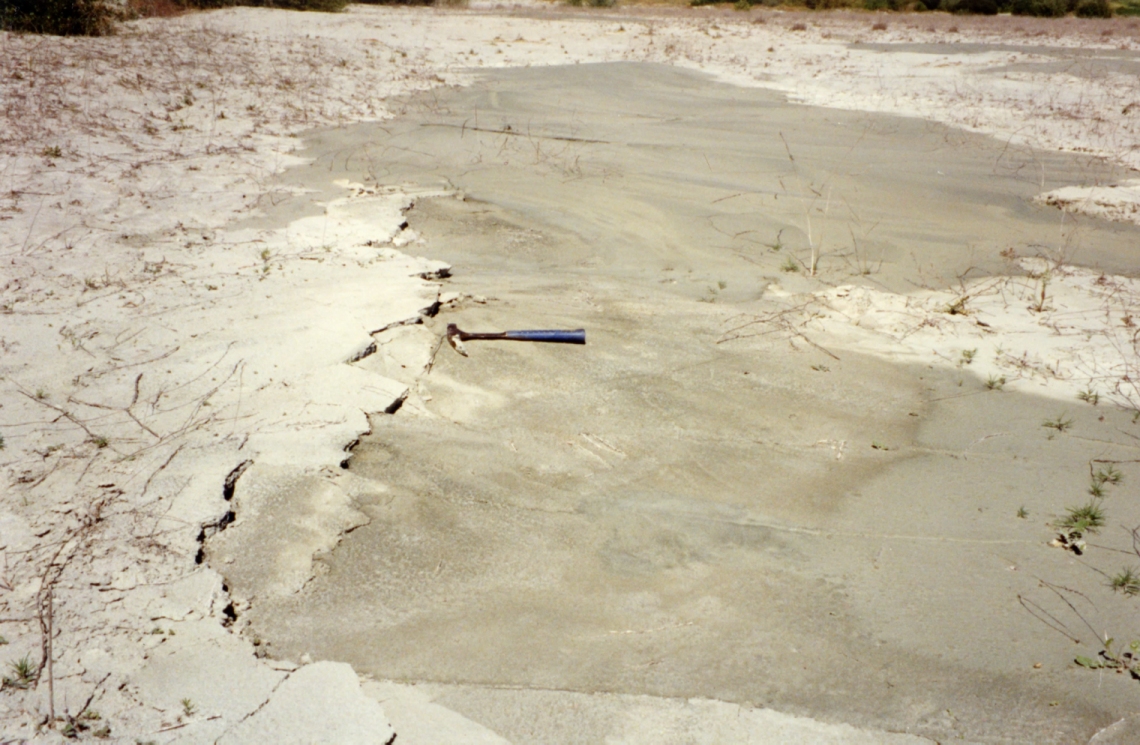
pressure of the soil cap. Boils can occur as conical spouts (shown at
right) or linear ridges (shown at left)
along the landside of the levee, and are usualy noticed prior to seepage-related
failures.
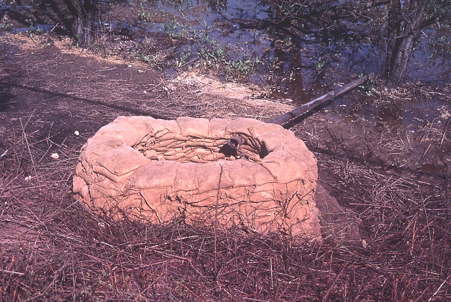
Figure 5
- Sand bags are commonly employed around recognized boils during
floods to increase
pressure
the excess pressure head and diminish hydraulic piping of fines from the
levee foundation.
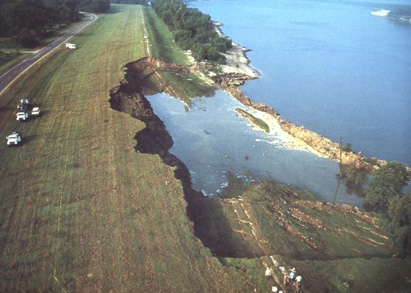
Figure 6 - Levee failures can also be caused by massive
slope failures, such as that shown
here, on the river side of the Marchland Levee in Louisiana, which occured
in 1983.
E-mail Dr. J David Rogers at rogersda@mst.edu.
![]()