FLOOD DAMAGE:
Evolving
laws and policies for an ever-present risk
J. David Rogers,
Ph.D., P.E., R.G., C.E.G., C.HG.
Karl F. Hasselmann Chair in Geological Engineering
Department of Geological Sciences & Engineering
Missouri University of Science & Technology
129 McNutt Hall, 1400 N. Bishop Ave.
Rolla, MO 65409-0230
INTRODUCTION
Flooding is a natural geologic
hazard that will always be with us. In
fact, virtually all the sediment deposited upon the continent are
deposited on well-defined flood plains, which also enabled our agricultural
development. Those areas have since
become prime real estate and support a large percentage of the population. This article provides a brief introduction to
the reasons for floods, their periodicity, the National Flood Insurance Program,
and the problems associated with estimating areas of likely inundation and
relative risk; revealed by the repeat occurrences of so-called “100-year”
floods with seemingly increasing frequency.
The balance of the article contains examples of the various theories
of liability presently applied to litigation in the United
States associated with common flood hazards,
drawing in large part from legal cases in California.
HISTORICAL
CONTEXT
The nation’s first locally-controlled
flood control agency was the Miami Conservation District, formulated in 1913
in the wake of the disastrous Dayton, Ohio flood of that same year, which
killed 600. The city fathers asked renowned civil engineer
Arthur E. Morgan to come to Dayton
and have a free hand in devising such engineering schemes necessary to prevent
such a tragedy from ever occurring again.
Morgan was a man with purpose and drive, who went on to become the
first director of the Tennessee Valley Authority (TVA) in 1934. Morgan astounded everyone by removing those
portions of downtown
Dayton which had encroached on
the historic channel of the Miami River. He enlarged the river channel and built enormous
levees. Then he then built three “flood
control dams”, or retention basins, on the Miami River
upstream of Dayton. Morgan also issued an edict which prevented
the reservoirs from ever being filled, to prevent hydropower and recreation
interests from becoming tempted to lessen flood storage and thereby, negate
the dam’s fundamental purpose (Morgan, 1952).
Morgan’s stringent flood control
measures have proven themselves to be prophetic time and again, as flood control
infrastructure in the United States
has repeatedly failed because of political and economic compromises to create
“multi-purpose reservoir projects”, to gain a broader base of support for
funding of dams. In the 1997 New Year’s
floods in northern California
the unprecedented number of dams and flood control infrastructure was unable
to protect the lower Sacramento
Valley because operators had gradually
lessened the flood storage capacity of each reservoir in order to promote
enhanced power generation, greater summer storage and recreation capacity.
Morgan’s 1913 warnings about the dangers of multiple-use reservoirs
were fulfilled, and California
suffered more than $4 billion in flood damages, despite having some of the
world’s largest flood control dams in place.
A fundamental problem in forecasting
flooding has been the absence of adequate flow records. In his last article for the American Society
of Civil Engineers, Professor Ven Te Chow of the University
of Illinois reminded fellow engineers
that in order to adequately predict a 100-year recurrence interval flow event,
one would need 1000 years of hydrograph records (Chow and Takase, 1977).
In most instances, project floods are based upon inadequate flow data,
extrapolated well beyond the range of scientific certainty and subject to
all kinds of flow adjustments, as discussed later.
Perhaps the best appreciation
of how poorly we predict so-called “maximum flood events” are some of the
flow records in California. The lower Sacramento River
recorded nine “100-year floods” during the 20th Century, in 1907,
1909, 1936, 1955, 1964, 1982, 1986, and 1997.
Southern California purported to have received
seven such events, in 1914, 1916, 1938, 1969, 1993, 1995/97 (depending on
location). At the time these extreme
flow events occurred each appeared “unprecedented”. Some of the increase in peak flow was likely
due to channelization and man-induced activities associated with agricultural
development and urbanization. It is
obvious that the estimates of 100-year recurrence frequency will continue
to evolve as more flow data is collected.
Following the disastrous 1927 and 1937 floods of
the lower Mississippi and Ohio
Valleys the U.S. Army Corps of
Engineers began to develop methods by which levees could be evaluated, engineered
and strengthened. This pioneering work
culminated in a better understanding of the limitations of man-induced flood
control and river training than had previously been appreciated.
By the late 1950s flood inundation models began to evolve which were
computerized in the 1970s and 80s to calculate inundation areas for the probable
maximum flood, as well as 100-year (1 chance in 100 of occurrence) and 500-year
(1 chance of 500 of occurrence) frequency floods, commonly used on government-sponsored
flood maps. But, because parcels are
developed in a piecemeal fashion, each one only a small part of an immense
watershed, the so-called “project flood” evolved.
A “project flood” is that frequency of occurrence felt to be within
economic reasonableness for the size and value of development contemplated. For government infrastructure, the “project
flood” value most commonly selected is half of the probable maximum flood,
and is usually something between a 50-year and 100-year recurrence frequency
event. Developers of small parcels
oftentimes attempted to install drainage infrastructure with between 10-year
and 25-year recurrence frequency, leading to a heterogeneous mix of drainage
improvements which are seldom, if ever, compatible.
In 1969 the Federal Emergency
Management Agency (FEMA) began to administer a Federally-mandated National
Flood Insurance Program (NFIP) Act of 1968 (42 U.S.C. 4001-4128, and Supp.
III 1985). This program sought to socialize
the burden for flood damage between those individuals who actually live in
flood-prone areas, and sets rates according to relative risk of occurrence,
based on computer simulations of flooding.
For example, people living within the 100-year frequency inundation
area are charged at a higher premium than those above the 100-year line, but
within the 500-year recurrence frequency level.
Damaging floods occurred in the
San Francisco Bay Area in 1955/56, 1962, 1963, 1964, 1967, 1969, 1973, 1982,
1983, 1986, 1993, 1995 and 1996/97. Five of these events were espoused to be 100-year
recurrence frequency events. This is
doubtful. A 100-year recurrence frequency
suggests that the river or stream flow has one-chance-in-100 storm events
of occurring at any given time. But, it’s not that easy. Other factors play a large role in determining
how high flood flows get against the bank at any given location. Some of these factors are listed in Table 1.
Table
1
Common
factors affecting accuracy of flood predictions
|
Factor |
Description |
|
Antecedent moisture |
How much rain has already been absorbed
by the ground, season-to-date. The
more saturated the ground surface, the greater the runoff from any
given storm. Landscape watering
can also lead to increased levels of antecedent moisture. |
|
Localized cells of intense precipitation
|
Very intense bursts of moisture in upland
areas can cause localized flooding and destructive debris flows which
clog drainage inlets, culverts, etc, which then leads to flooding
|
|
Duration of storm events |
The longer storms stall over any given
area, the greater the flooding |
|
Changes in vegetation within the watershed |
Changes in land use (such as grazing)
and vegetation will lead to changes in the time-to-concentration of
runoff to local creeks and rivers.
|
|
Development of the watershed |
The more hardened surfaces, such as
roofs, walkways, pavements and lined storm drainage channels, the
greater the peak runoff. A
400% increase is not unusual, commonly leading to down cutting of
unimproved channels |
|
Unnatural constriction of flow |
The placement of hardened improvements
in channels, such as culverts, rip rap, retaining walls, or; natural
impediments to flow, such as landslides, eroded soil, trees, organic
debris and natural storm-laden debris, invariably cause localized
hydraulic chocking of channels, leading to tail water inundation of
previously un-flooded areas |
|
Changes in weather patterns |
Frequency and probability-based flood
flow assessments are based upon the assumption that weather patterns
are essentially unchanging. Data
collected since 1849 would suggest otherwise, weather patterns are
always changing. |
|
Mistakes in flood plain management |
Whatever can go wrong in routing floods
via use of planned releases from flood control reservoirs, eventually
will. |
|
Failure of flood control infrastructure |
Despite the best intentions, infrastructure
elements, such as levees, dam spillways and conduits, can fail, most
often during peak usage. Levees
are particularly sensitive to duration of flood flow |
|
Accuracy of topographic information |
The accuracy of topographic information
within the watershed being studied will exert keen influence on the
areas predicted for inundation |
|
Accuracy of channel roughness estimates |
Channel hydraulics assessments are dependent
upon estimates of channel roughness, which are highly variable in
unimproved channels, and subject to change, depending on frequency
and depth of flows |
|
Accuracy of input hydrology |
Flow assessments are only as good as
the estimates of precipitation upon which they are based. An array of antecedent moisture levels needs
to be evaluated in order to make conservative predictions of flow.
|
|
Accuracy of the computational methodology
chosen |
A
wide array of computational models exists, the most commonly employed
being HEC-2, developed by the Army Corps of Engineers. However, flow predictions are built upon the
detail and accuracy of input information, such as the number of channel
cross sections.
|
A careful study of the factors
listed in Table 1 should present the reader with sufficient reason to suspect
that most of these factors affect every stream in developed watersheds of
the United States.
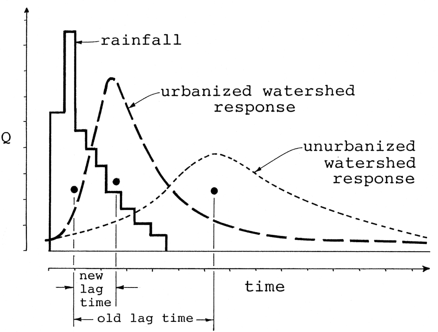
Massive changes in vegetation, land use and weather patterns have led
to increased downcutting of channels in coastal California,
with the largest watersheds responding first, followed by their own tributaries
(Bull, 1991). Examples of recently
entrenched channels can be seen all over Contra Costa, Alameda
and Sonoma Counties. 25 years ago most hydrogeologists believed that
the downcutting was associated with increased development, but careful measurements
have shown the downcutting appears to be of similar magnitude within non-developed
watersheds as well; leading to the conclusion that other factors, such as
vegetation, land use and weather patterns are the real culprits (Rogers,
1988).
Some of the most common forms
of flood damage are presented in Figures 1, 2 and 3.
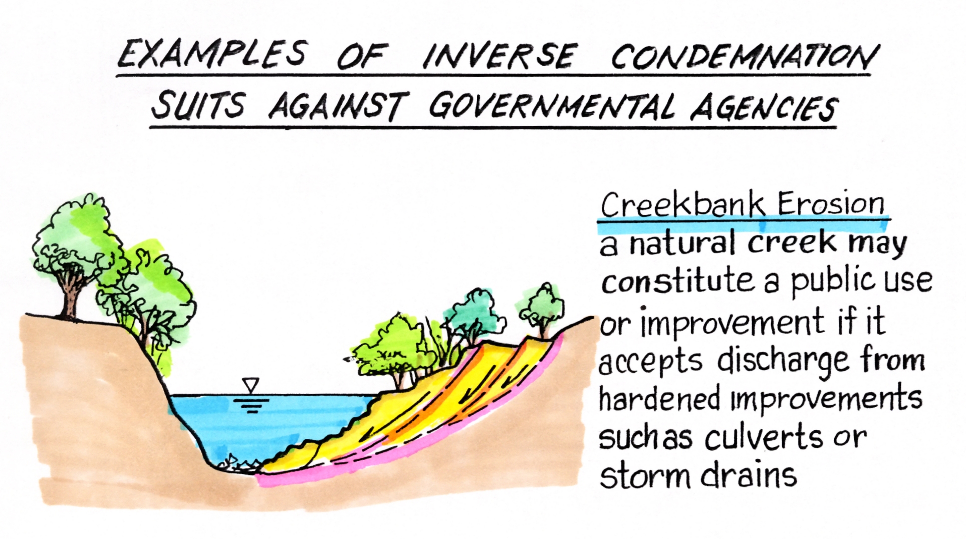
For public agencies, plugged culverts are by far the most onerous,
giving rise to inverse condemnation suits by adjoining property owners whose
properties are damaged (van Alstyne, 1969).
THEORIES
OF LIABILITY APPLIED TO FLOOD DAMAGE
Damage
Ascribable to Unchanneled Surface Waters
California
case law has generally stated that liability may follow from damage by naturally‑occurring
run‑off, or surface waters only if the
upper landowner causes the damaging flooding by his unreasonable or arbitrary
acts. The most cited case is the area
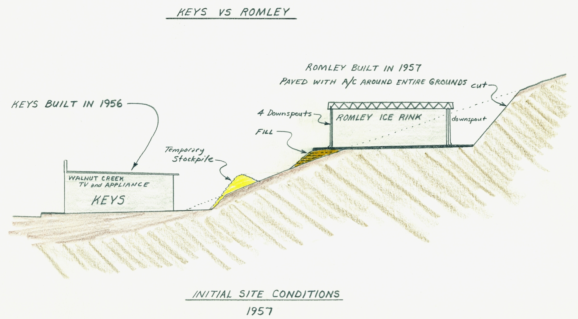
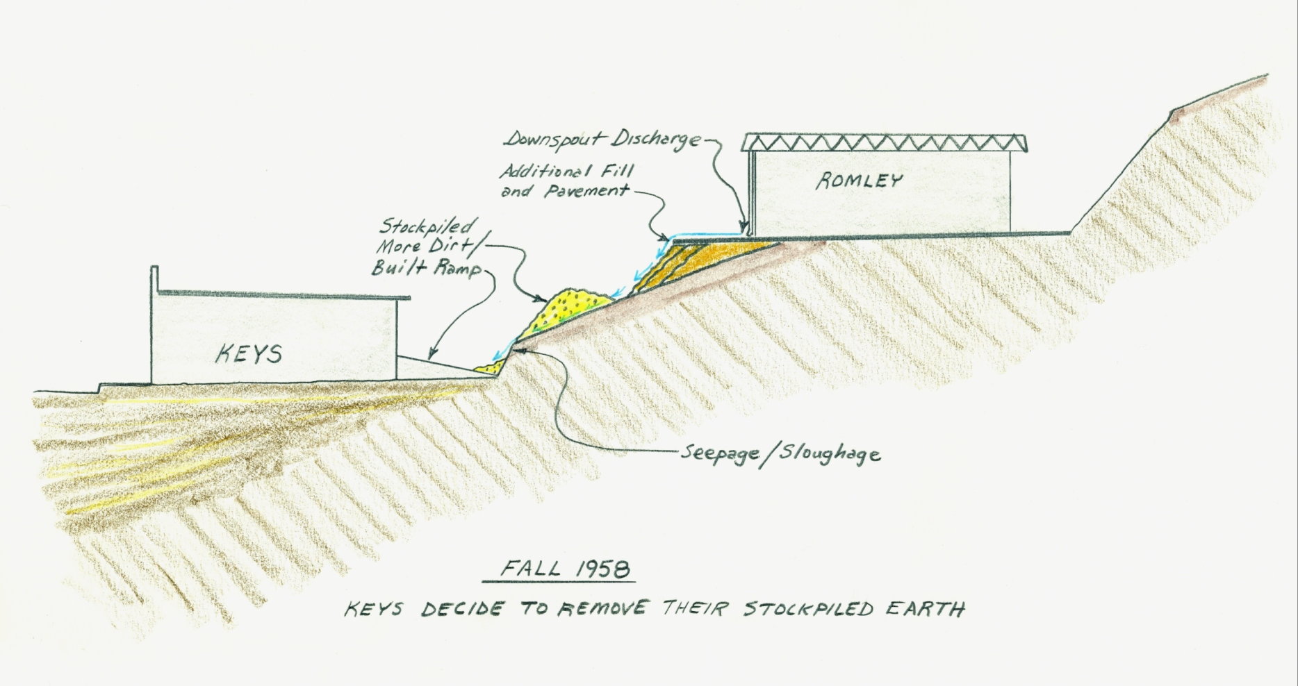
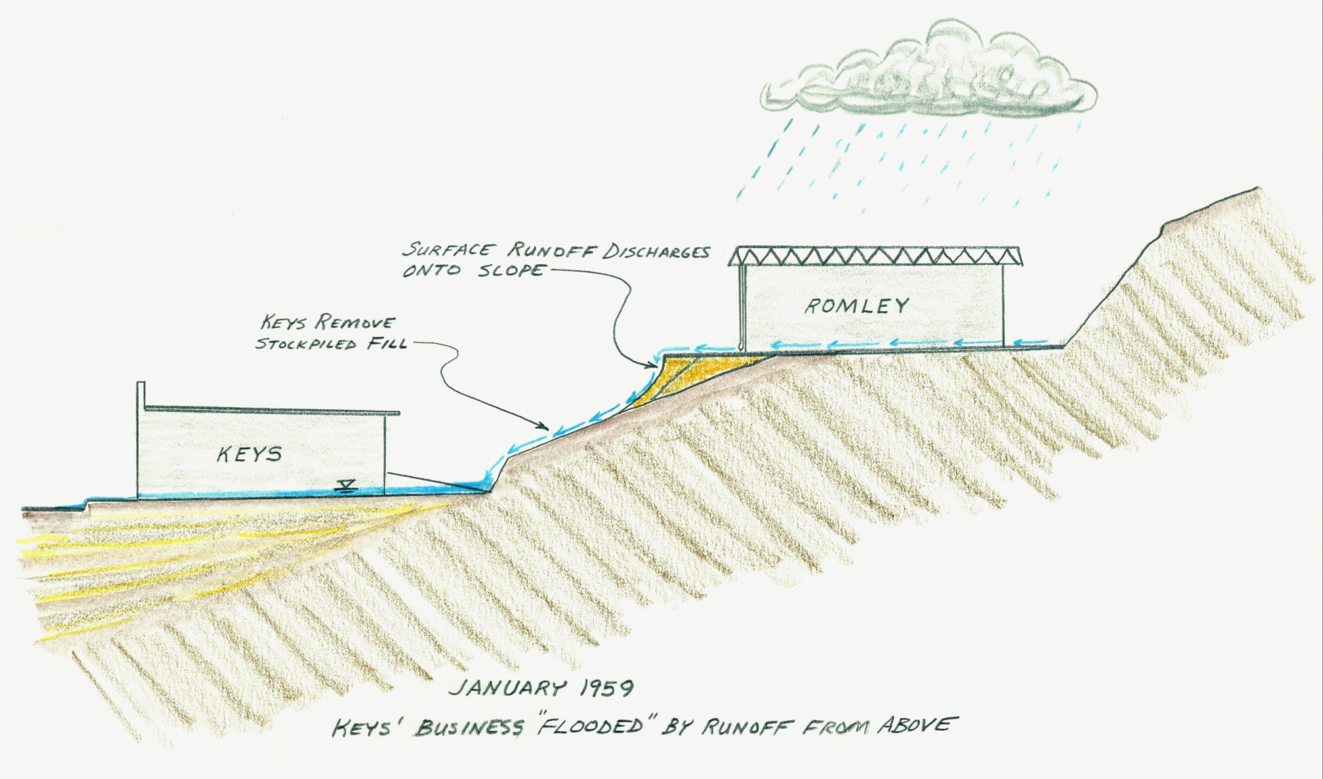
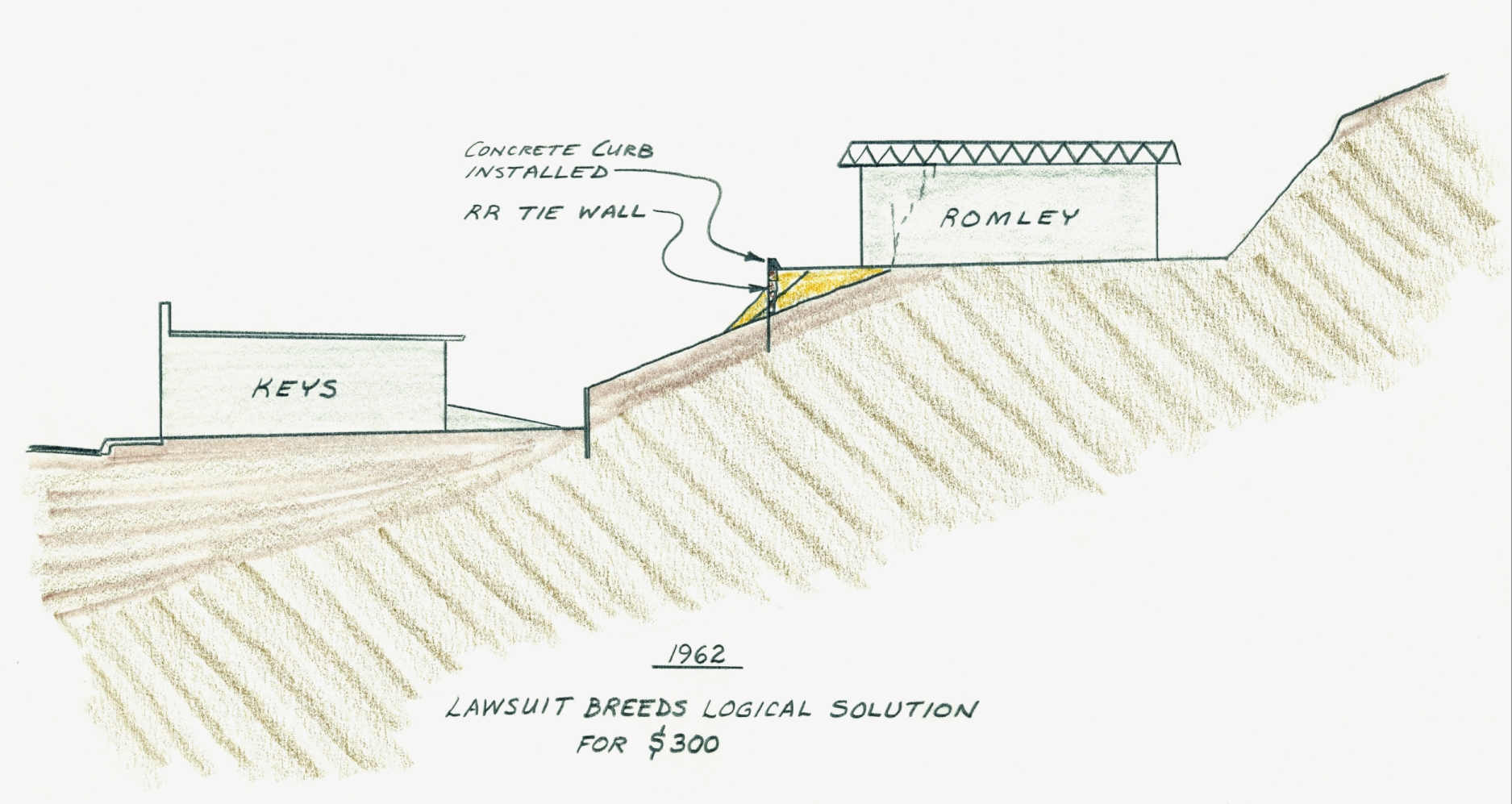
of surface run‑off is Keys versus Romley (1966) Cal.
2d. 396. In this case, the owner of
an electronics store in Walnut Creek
(Keys) was happily minding his own business until an adjacent, uphill property
was developed into an ice rink by Romley.
The run‑off from Romley's roof and parking areas was subsequently
concentrated on the newly‑filled slope above and behind Keys' store. When severe rains came, soil slumped on the
newly‑filled slope and Romley's run‑off was preferentially directed
into Keys' store, causing him damage (see Figure 4).
Keys sued and eventually prevailed,
therein making this case the pre‑eminent example of the so‑called
"Law of Reasonable Use" wherein
all owners of improvements must act in a reasonable and competent manner
to combat rainfall‑induced run‑off.
"Common
Enemy Doctrine"
The common enemy doctrine evolved
from the same sort of flood cases which gave rise to the Natural Watercourse
Rule (discussed later). The difference
lay in surface or near channel "improvements", such as protective
barriers, dikes, and levees which offer protection from flood water damage.
The common enemy doctrine held that such barriers could be constructed
with immunity, even if the barrier subsequently caused the diversion of flood
waters onto the land of others.
The early California
courts felt this exclusion necessary so as not to punish the "good faith
improver" who installed his flood control works or barriers. After all, why should an adjacent neighbor,
who fails to spend the money necessary to protect his property, be able to
punish those who do? The common enemy
doctrine was a way of encouraging adjacent landowners to make like improvements.
The landmark plaintiff cases were generally made against reclamation
districts and railroads.
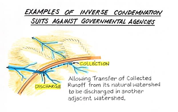
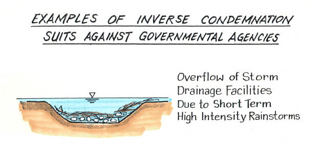


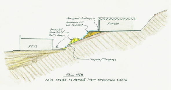
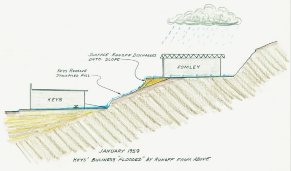
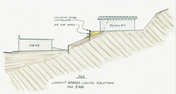
Figure 4
- In the case of Keys vs Romley (1966),
the Doctrine of Reasonable Use was adopted to pertain to collection and conveyance
of surface waters
on improved parcels.
The uphill owner, Romley had constructed his improvements in a manner which
is served to unnaturally concentrate run-off
onto a cut/fill slope
above and behind Keys’ store. Asphalt curbs, drop inlet catch basins, and
piped outflow were required to mitigate the problem.
Figure
5
The
“common enemy doctrine” reduces the potential liability of a “good faith improves”
who takes reasonable action to prevent or retard future flood damage, even
if said improvements promote future damages downstream.
However, the "common enemy doctrine" does not relieve landowners of liability
for negligence when his diversion of surface water damages another's property.
In 1987, the California Court of Appeals reversed a lower court decision
that had upheld the common enemy doctrine. The CEB Real Property Reporter (1987) summarized
this important case as follows:
Linvill v Perello (1987) 189 CA3d 195
Both
parties' lands were adjacent to a natural watercourse which periodically breached
its banks during times of flood and caused waters to flow across the properties
without significant damage. Defendants
then built a levee on their land which directed all the water across plaintiffs'
property, causing personal injury and property damage. Plaintiffs sued for negligence. The trial court granted defendants' motion for
summary judgment based on the common enemy doctrine, which allows a landowner
to build protective barriers against flood waters on his property, even if
the barrier then diverts water onto the land of others (see Figure 5).
The
court of appeal reversed. Under CC 1714, one is responsible
for injuries caused by want of ordinary care in the management of one's property.
This principle also applies to natural conditions on land.
Sprecher v Adamson Cos.(1980) 30 C3d 358. Under Rowland
v Christian (1968) 69 C2d 108, an exception to this rule should not be
made unless there is a clear public policy reason to do so.
The
court concluded that there is no policy reason to create an exception to the
rule for surface waters, as the common
enemy doctrine does. Imposing this
rule will not necessarily prohibit the development and improvement of land
along rivers. The California Supreme
Court has declared that the utility of the possessor's use of land is a relevant
consideration in determining the propriety of his alteration of the flow of
surface waters, see Keys v Romley
(1966) 64 C2d 396. The court also noted
that the previous supreme court case upholding the common enemy doctrine with
regard to flood waters, Clement v State
Reclamation Bd. (1950) 35 C2d 628, was decided 18 years before Rowland and, therefore, is probably no
longer applicable.
Old
Civil Law and the Natural Watercourse Rule
In basic terms, the “civil law rule” developed
within California sought to
recognize the servitude of natural drainage courses: the lower owner must
accept drainage onto his land, and the upper owner has no right to alter drainage
so as to increase the downstream burden. But, courts quickly appreciated the Pandora’s
Box allowed by such a theorem if every inhabitant of a given watershed normally
and naturally subject to flooding is allowed to file a cause of action against
upstream parcel owners who they allege have altered the flow.
Beginning with San Gabriel
Valley Country Club vs. County of Los Angeles (1907) 182 Cal.
392, courts granted immunity to upstream landowners who make drainage improvements
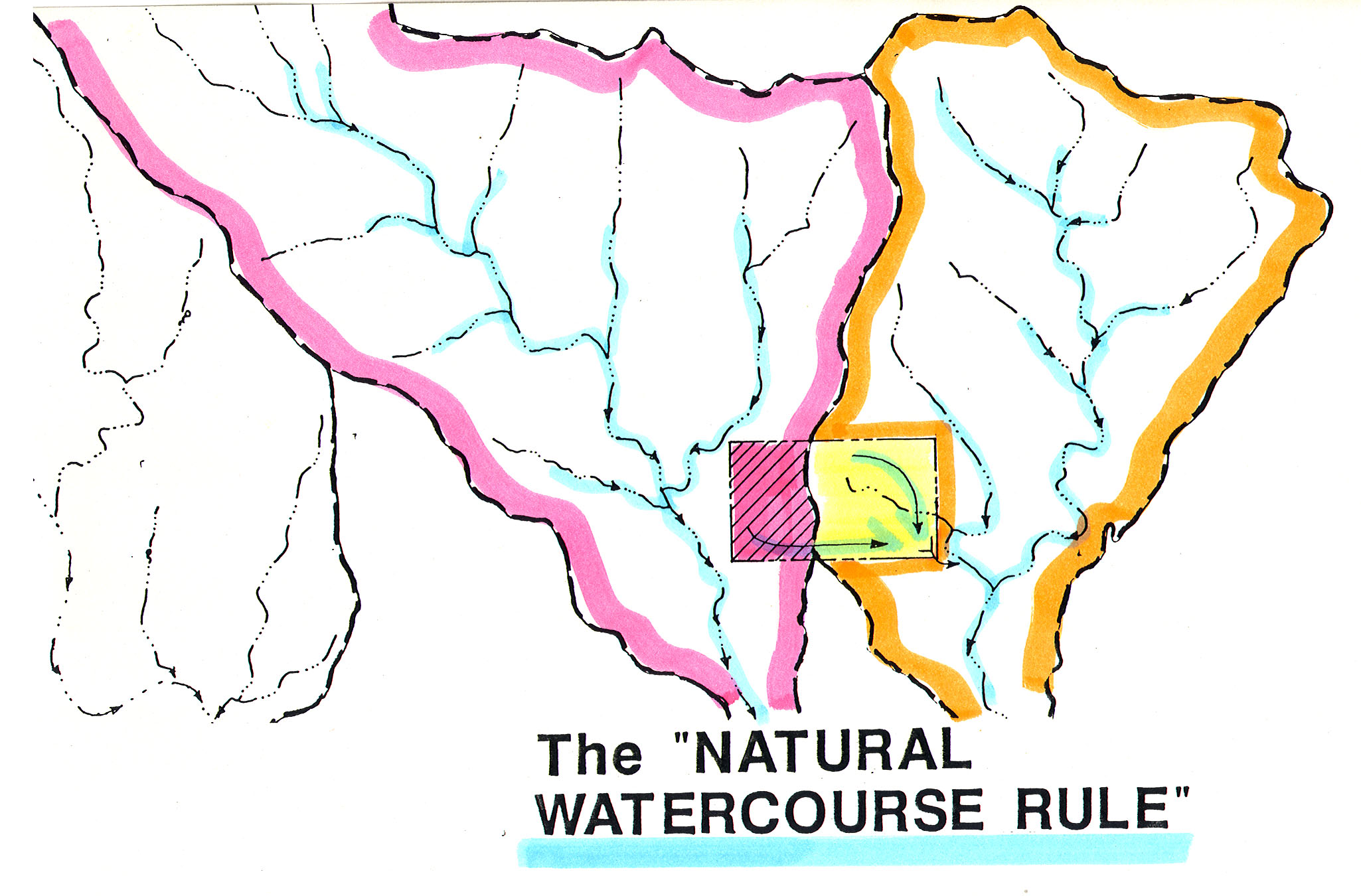
as long as those improvements conform to three basic premises:
1. They have not diverted run‑off out
of its pre‑development, or natural
watershed (see Figure 6);
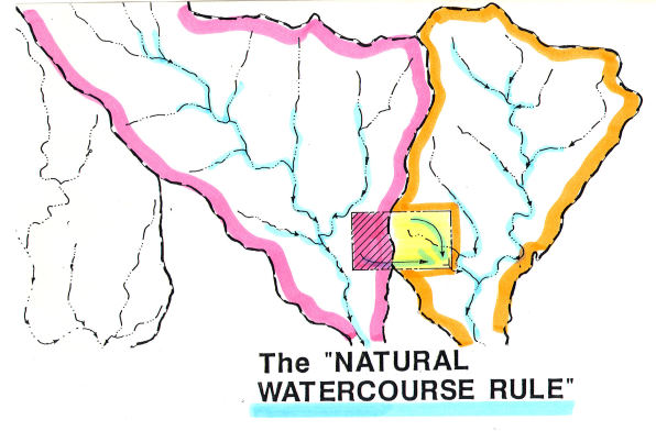
Figure 6
- Protection under the legal theorem of the “Natural Watercourse Rule”
is violated when surface waters within
a natural within a
natural watershed are collected and unnaturally discharged in another watershed.
Figure 7 - A
natural watercourse is defined as a naturally-occurring stream, river, creek,
runs, or rivulet. The stream need not
flow continuously, it may sometimes
be dry. It must be something more than mere surface run-off over the face of the land.
2. Run‑off is conveyed to the natural
stream course (with bed and bank) that the run‑off would have naturally
flowed to (see Figure 7; and
3. The upstream improver has not created
unnatural diversions, obstructions, or
trespassed into the high‑flow channel cross section which could be construed
as unreasonable, negligent, or worthy of trespass (see Table 2).
The liability relief once spelled
by the old Natural Watercourse Rule
cannot be understated. Countless flood
cases are caused by increases in peak stream flow ascribable to upstream development.
As shown in Figure 8, upstream improvements such as impermeable surfaces
(pavement, roofs, gutters, culverts, etc.) bring the run‑off to a natural
stream course much more quickly than in an unimproved
or "agrarian" state.
The Natural Watercourse Rule had
been challenged unsuccessfully in a large number of cases (see San Gabriel
Valley Country Club {1920} and Archer {1941}), but was eventually
overturned in the Locklin vs Lafayette,
et al case in 1993. Synopses of these
cases follow:
San Gabriel Valley Country Club vs County of Los Angeles (1920) 182 C.392.
"The improvements must follow
the natural drainage of the country. If
the water is diverted out of its natural channel and discharged into a different
channel or upon neighboring land, the diverter is liable to the owner whose
land is injured."
Archer vs City of Los
Angeles (1941), 19 c. 2d 19
Archer lived by a lagoon near
the ocean. Tributary watershed to the
lagoon area was urbanized, thereby decreasing run‑off infiltration and
time to concentration and increased peak flow thereby ensued. A non suit judgment was granted in favor of
the City. Judgment Statement said "...a
lower owner has no right of redress for injury to his land caused by improvements
made in a stream for the purpose of draining or protecting the land above,
even though the channel may be inadequate to accommodate the increased flow
of water resulting from the improvements."
In light of the older, established
court decisions, it appears clear that an upper landowner may act with relative
impunity in collecting and discharging water from his property into a natural
watercourse ‑ even though the
additional water may exceed the capacity of the downstream channel.
In addition, it is equally clear
that an upstream owner may improve the watercourse to facilitate drainage
flow from his property, and the fact that said improvements artificially increase
the quantity or accelerate the velocity of the stream flow within the channel
is an insufficient basis of which to impose liability.
Locklin vs City of Lafayette
(1992) 11 CA4th 1, 13 CR2nd 889
A group of property owners living
along lower Reliez Creek, an unimproved channel, alleged in an inverse condemnation
action that the City, County, Walnut Creek,
BART and Caltrans benefited from the channel’s use as a quasi storm runoff
channel, and that because of increased flow due to public improvements, their
channel had been unnaturally eroded. In
1988 the trail court granted motions for a nonsuit for 4 of the 5 defendants,
citing the Natural Watercourse Rule, which then allowed the establishment
of drainage improvements within a natural watercourse, even if said improvements
cause increased runoff downstream. This decision was affirmed by the appellate
court. The lower courts felt that the
plaintiffs had not demonstrated that the public agencies had exercised the
kind of control necessary to convert the creek into a public improvement,
despite accepting flows
from hardened improvements located upstream.
In February 1994 the case then
came before the California Supreme Court (7Cal 4th 327, 1994), who partially
overturned the decision, there by rescinding the natural watercourse rule. The Supreme Court eliminated the immunity afforded
by the Natural Watercourse Rule and instead held that anyone or any agency
can be held liable if they act unreasonably in the collection, conveyance
and discharge of surface waters. The
Court also imposed an obligation on the part of individual property owners
to take reasonable actions/precautions to protect their banks from threats
of erosion and flooding; and that, if said individuals act unreasonably, they cannot recover
for damages which then occur (similar reasoning to the common enemy doctrine,
discussed elsewhere). The Locklin
decision means that public agencies, in particular, will no longer be granted
summary judgements in flood cases involving natural channels, as had been
the case for the previous 85 years.
Negligent Diversion or Disturbance
of a Natural Watercourse
Even with the recent overturning
of the natural watercourse rule, flood water damages have always resulted
in liability if there is a diversion
of the waters onto property which would otherwise have been unaffected (see
Van Alstyne 1969, p. 454). In inverse
condemnation liability, the proximate
cause of damage is a major consideration.
In other words, was a diversion
or a negligent act a substantial cause of the alleged loss? In legal terms, the burden of "proof"
often times lies in proving that the flood‑induced damage was over
and above that which would have occurred in the absence of a structure or
activity that gave rise to an unnatural diversion or protuberance of the natural flow regimen. Those factors most often cited as being Aunreasonable behavior@ inexpert testimony are summarized
in Table 2.
TABLE
2
Activities
Undertaken Within Channels Commonly Deemed “Unreasonable”
|
Collecting surface waters from one natural
watershed and concentrating into another |
|
Concentrating discharge in any manner
of hardened improvement, such as lined channel, culvert or pipe, in
such a manner as to cause unnatural increase in runoff velocities
and/or concentration of runoff quantity that actually leads to unnatural
or accelerated erosion, which occurs as a direct consequence
of said improvement |
|
Causing unnatural concentrations of
surface flow due to physical encroachment on an unimproved (natural)
channel within the FEMA 100-year recurrence interval flow area |
|
Causing unnatural bank erosion through
excavation or dredging of the channel substantially outside the centerline
(thalweg) of flow |
|
Creating obstructions to flow by blockage,
dumping or inadequate diversion of any natural channel or swale, or
of an improved channel (common in construction related activities) |
|
Failure to maintain hardened drainage
improvements within a reasonable time interval of learning that flow
capacity has been hindered or impaired by any manner of hazard, such
as catchment of organic debris, siltation, accidental mechanical damage
or weathering |
|
Negligent design of channel improvements
|
Two principal cases pertaining
to activities within channels are most often cited. Flooding ascribable to inadequate runoff collection system is
not negligence per se, as described in the Tri-Chem decision. The Ektelon and Linvill cases involved alleged
negligent activities within channels, and thereby came to be judged under
doctrines of reasonableness now commonly associated with surface water collection,
conveyance and discharge.
Tri‑Chem
vs Los Angeles Flood Control District (1973) 60 Cal.
App. 3d 309
The plaintiff owned a parcel of
naturally low‑lying ground in an industrial tract in Torrence. Run‑off from natural slopes to the south
caused run‑off to collect on the property. One cross street culvert served to drain the
plaintiff's property (see Figure 8). The
capacity of the drainage trunk line into which the plaintiff's culvert entered
was only that expected from a 2 or 3‑year frequency storm, the mouth
of such line having been built in 1940. In
January 1969, during a 17‑year recurrence frequency storm, the capacity
of the trunk drain line was exceeded by a factor in excess of 200%. This increased factor resulted in the breaching
of a sandbag dike, which resulted in the flooding of the plaintiff's property.
The Court upheld the Flood Control District's assertion that it was
not liable for flood damage on the
basis that its conduct, in and of itself, was not a proximate
cause of the plaintiff's damage. The
City and Flood Control District were further able to contend that they were
not negligent in maintaining their portion of the
flood control system. The Court
found that, although the flood control improvements were aged and undersized,
they still constituted an improvement
which provided benefit to the plaintiff, without which flooding would have been worse.
Ektelon
v City of San
Diego (1988) 200 CA3d 804
A downstream riparian owner sued
the City of San Diego and others
for flood damages caused by the City's construction of upstream flood control
facilities. The trial court granted
defendants' motion for nonsuit, but the court of appeal reversed.
The trial court had relied on
Archer v City of Los Angeles (1941)
19 C2d 19. The court in that case held
that an upstream owner is not liable for injuries resulting from improvements
made to protect the upstream land even if the channel is inadequate to accommodate
the subsequent increased flow of water. In a later case, however, the California Supreme
Court held that an upper landowner must act reasonably with regard to the
discharge of surface waters from his land.
Keys v Romley
(1966) 64 C2d 396. This principle of reasonableness applies to
stream waters as well as surface waters.
Linvill v Perello (1987) 189 CA3d 195, 234 CR 392 (10 CEB RPLR
94 (June 1987)). As a consequence of
Linvill, upstream flood control improvements are now subject to principles
of ordinary negligence. As noted in
Linvill, application of negligence principles
will not hinder the development and improvement of land along river bottoms;
a rule of reasonable conduct, which weighs the utility of upstream diversion
of flood waters against the gravity of harm caused to downstream lands, is
not inconsistent with development concerns.
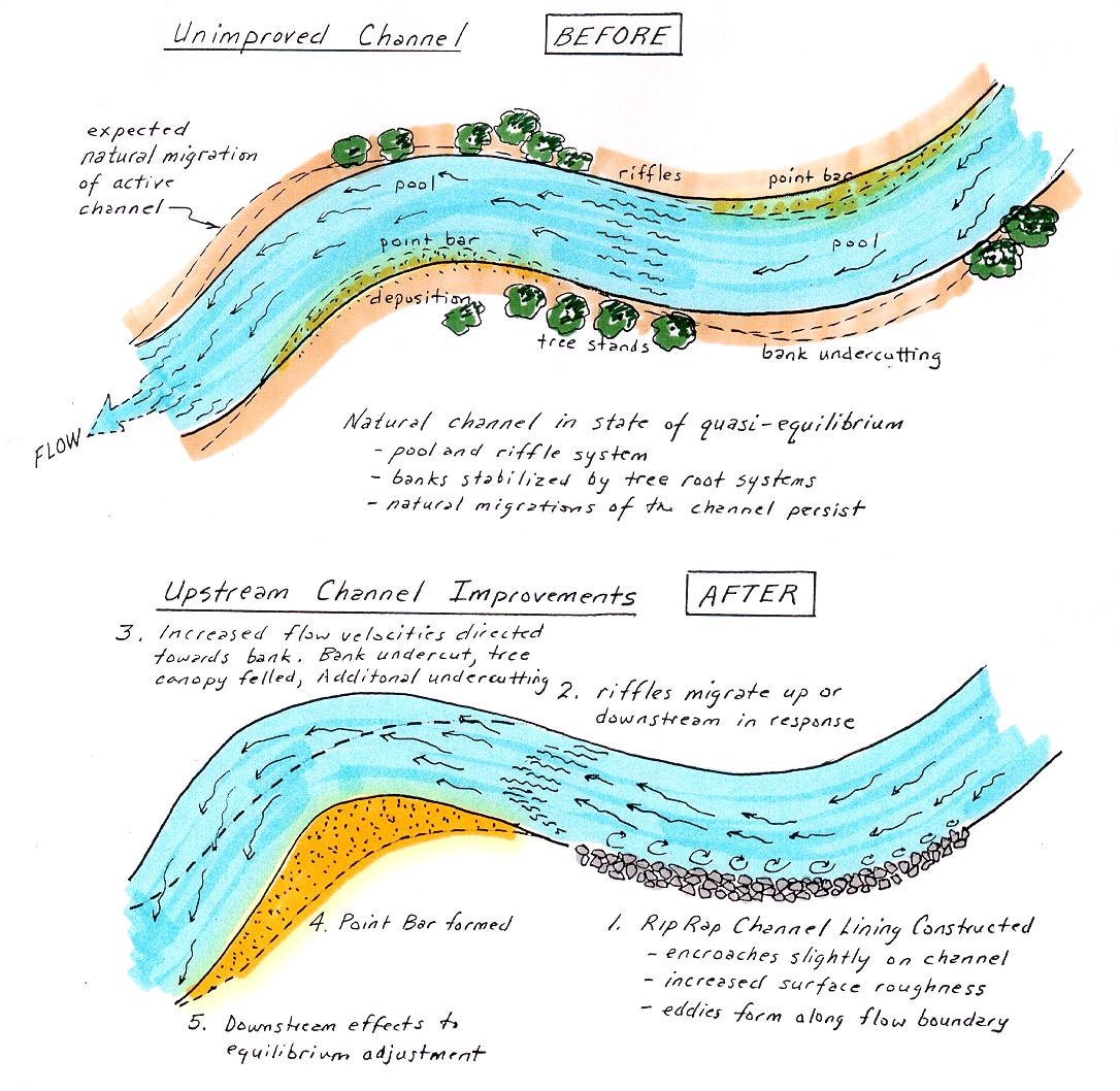
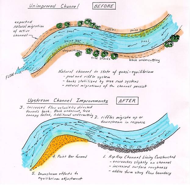
Typical Hydrograph
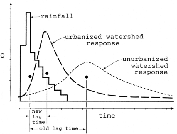
Figure8
- Schematic representation of changes in peak stream flow due
to adjustment of a perturbed watershed. The lag time is the interval between
the mean rainfall
occurrence and
the mean run-off in response to such rainfall. The lag time can be significantly
reduced as the watershed run-off characteristics
are changed by paving
and urbanization,
vegetation change, over grazing, or weather pattern change. Most California
streams have made marked adjustments over the
past century, due,
in part,to
all of the above-cited factors. The creeks with the greatest flows adjust
first, with successively smaller tributaries adjusting more slowly, due totheir
lower
stream
power. Arid areas generally take longer to adjust than do areas of greater
precipitation and run-off. Many inverse condemnation suits seek damages
from
public agencies
on the basis of drainage improvements reducing lag time, and therein increasing
peak flows which are more destructive and erosive.
Common Sources of “fault” in
Flood Cases Involving Public Entities
In order to trigger inverse condemnation
liability a plaintiff must demonstrate some manner of preventable fault on the part of the public
entity. The burden of proof for the
plaintiff in a flood control/levee failure case normally focuses on the demonstration
of:
a. failure to
properly maintain the levee structure in such a manner that such neglect was a direct or significant factor in the levee's subsequent failure; or
b. that the levee
or its appurtenant structures were originally constructed in a negligent manner
which significantly contributed
to the levee's failure.
Allegations of negligence
in design or maintenance are usually "necessary" because they are
the only tried and true avenues of "levee liability". In order to trigger maintenance liability, some
demonstration of the levee owner's (respondent) legally imposed duty to maintain the levee will first have to be made.
Such allegations have failed on several occasions with actions involving
the L.A. County Flood Control District, having
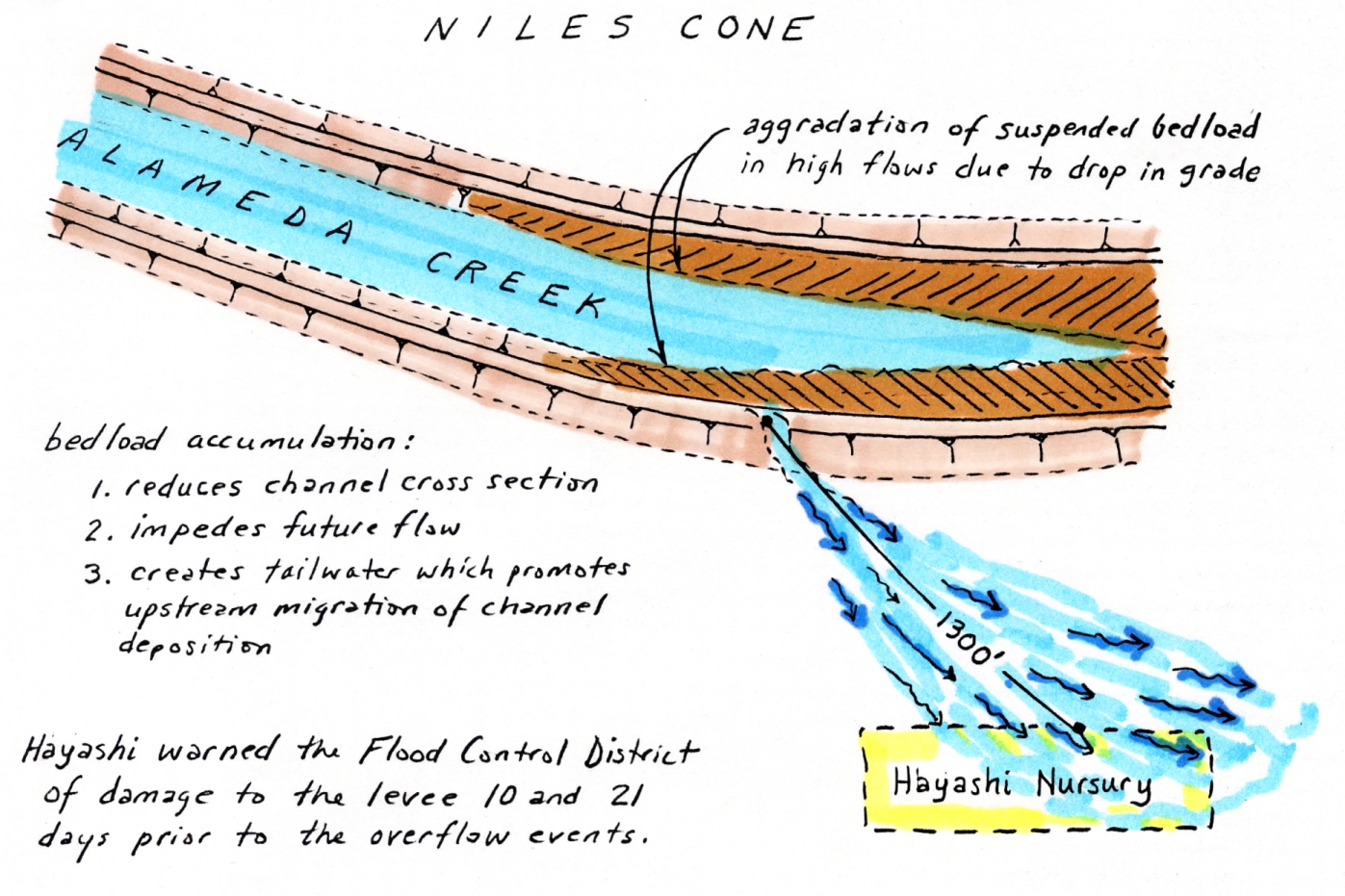
been formed by referendum in 1916 (see citations, bottom p. 587, in Hayashi vs Alameda F.C.D., (1959) 167 Cal App 2d p. 584) (shown in
Figure 9). Districts formed at later dates may have somewhat more explicit
mandates with respect to maintenance. In
the Hayashi case, Alameda F.C.D. had been formed in 1949 with a more explicit
mandate for maintenance responsibility. In
that case, the court asked:
"after
the public improvement is constructed, is the District, after notice, under
an obligation to maintain it (the levee) in such a manner so as not to injure
the adjoining property as the result of negligent maintenance?"
In the Hayashi
case, the plaintiff had notified the District 10 and 21 days prior to the
subject losses. This prior notice sealed the case, and most
subsequent cases of proven prior notice, in the plaintiff's favor.
The Hayashi case also went
on to explore some of the "common enemy" flood control doctrines
normally brought out by public agencies in their defense. These include:
a. "Under the general common law, there
can be no doubt that a landowner is responsible for damages caused by the
negligent disrepair of an artificial structure." (taken
from Hayashi)
But, it would appear
that liability is only incurred if it can be shown that reasonable maintenance would have disclosed the problem and that the
problem could have been made reasonably safe through quick and judicious repair;
or that the owner/maintainer were put on notice that a repair might be needed
and failed to heed such notice (thereby possibly being negligent).

Figure 9
- In the case of Hayshi vs. Alameda County Flood Control (1959), the plaintiff
prevailed in his flood damage suit because the District’s mandate
specifically includes
flood control maintenance responsibility. Hayashi had warned the District
of a weakened levee area 10 and 21 days prior
to
the actual breach
and the Court found the District liable for not providing reasonable maintenance
in light of the prior notice of the problem.
The Hayashi Decision (p
590) went on to state:
b. "If a structure suddenly and without
the fault of the processor becomes dangerously dilapidated, the possessor
is not subject to liability for any harm done thereby to persons outside
the land until he has had an opportunity, by the exercise of reasonable care,
to make the structures safe."
In conclusion then,
it would appear that a levee owner in
California is only liable for flood damage caused by
the negligent maintenance, construction, or permitting hazardous activities
in proximity to the levee.
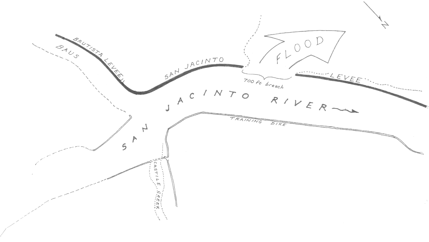
Belair
vs Riverside County Flood Control District (1988) 47 Cal
3d 550
The most severe challenge to the
doctrine of proving unreasonable conduct was the recent case of Belair vs Riverside County Flood Control
District. In 1980, a flood
control levee on the San Jacinto
River failed at a flow volume only
29% of that which the channel had been originally designed to function by
the U.S. Corps of Engineers in 1960. Parts of San Jacinto
were flooded. Various property owners
sued the flood control district and State for damages under inverse condemnation
theory. Unable to show fault on the
part of the State or the District, the plaintiffs' attempted to establish
inverse condemnation tort without fault. But,
the trial court entered judgment for defendants and the court of appeal affirmed.
The California Supreme Court also affirmed in December 1988, but on
different grounds.
The levee was designed and constructed
to contain a flood discharge of 86,000 cubic feet per second (cfs), and the
discharge at the time of breach was only 25,000 cfs (see Figure 10). Plaintiffs contended that this fact established
that the levee had failed to function within its design capacity, which was
all that they were required to prove. As
in the case of Tri‑Chem, the trial court had also found, however, that
plaintiffs' properties had been subject to periodic flooding before construction
and that the levee had not increased the risk of flooding.
On the basis of this finding, the court of appeal had held that the
levee was not the proximate cause of plaintiffs' damages (the rain was).
The supreme
court rejected the court of appeal's proximate cause analysis, concluding
that the levee was a substantial concurring cause because it was designed
to contain 86,000 cfs and it failed to function as intended. The prior flooding was not significant because
owners had been induced to improve their property in reliance on the protective
ability of the levee. The court also
held that plaintiffs were not required to prove that the levee had increased
the risk of flooding; a public improvement need not worsen a pre‑existing
hazard to give rise to liability for inverse condemnation.
Nevertheless, in a flood control
case, plaintiffs cannot rely on a simple strict liability theory. The rule of Albers v County of Los Angeles (1965) 62 C2d 250, 263 ‑ i.e., imposing liability for any actual
physical injury to real property proximately caused by the improvement as
deliberately designed and constructed ‑ is subject to the exception
established by Archer v City of Los
Angeles (1941) 19 C2d 19, 24, which recognized that, in some situations,
the state has a right to inflict damage, based on the common law right of
landowners to erect barriers to ward off flood waters (known as the common enemy doctrine). However,
a public agency engaged in the activity of flood protection must at least
act reasonably and non‑negligently.
"[The fact that a dam bursts or a levee fails is not sufficient,
standing alone, to impose liability. However,
where the public


Figure
10 - The San Jacinto Levee was designed and built in Riverside
County under the auspices of the
Los Angeles District of the U.S. Corps of Engineers in 1960-61.
The levee failed in 1980, while experiencing a flow of only 29% of design-channel
capacity. A protective rip-rap apron
was designed for the river side of the levee
extending 10 feet below the channel bed, shown
in the lower inset above (Edwards, 1982). Unfortunately, the on-site materials were not
adequate to provide the proper
percolation
filter between the rip-rap and the sandy loam soils comprising the dike embankment
(Sciandrone, et al, 1982). It is likely that a helical underflow current
developed against the inside face of the levee just downstream of the turn
shown above. This downward current likely undercut the levee well below the
dry channel bed
and
succeeded in causing hydraulic piping of the levee materials through the rip-rap.
The plaintiffs tried to establish inverse condemnation sort without
showing
fault on the part of the defendant.
agency's design, construction,
or maintenance of a flood control project is shown to have posted an unreasonable
risk of harm to the plaintiffs, and such unreasonable design, construction,
or maintenance constituted a substantial cause of the damages, plaintiffs
may recover regardless of the fact that the project's purpose is to contain
the 'common enemy' of flood waters" 47 C3d at 565.
In this case, plaintiffs failed
to establish that the flood damage was the result of any unreasonable act
or omission by the defendants. Therefore,
the Supreme Court affirmed the judgment in defendants' favor.
Although Belair stands
as a landmark decision affirming the torts protecting flood control districts,
the Supreme Courts' recognition that the levee's failure at something less
than its design capacity opens a tort liability door for future plaintiffs,
especially those other than flood control districts (i.e.
reclamation districts, municipal water agencies, etc.).
DRAINAGE
EASEMENTS
The expressed purpose of most
drainage easements is for storm water drainage, including construction access
or maintenance of work, improvements, and structures, and also for the clearing
of obstructions and vegetation.
If evidence establishes that there
has never been any construction or maintenance of any works, it can
be shown that the Public Agency never exercised any dominion, or control,
over the channel ‑ thereby negating an implied acceptance cause of action.
Formal acceptance of easements
requires an ordinance or resolution of the governing legislative body which
has jurisdiction, expressly accepting the offer of dedications. See County of Inyo vs Given (1920),
183 C. 415, 191, p. 688 and Santa Clara vs Ivancovich (1941)
47 C.A. 2d 502, 188, p. 2d 303.
Generally speaking, there are
two ways that easements can be accepted via the Subdivision Map Act:
a. Public entity expressly accepts the offer
of dedication on the final map (becomes effective when map is filed) Government
Code 66477.3.
b. Official Resolution of the Public Entity
accepting an offer of dedication Government Code 66477.3.
Once there is an
offer of dedication, the offer remains open and cannot be revoked, except
as provided by statute. Government
Code 66475 and 66477.2.
Even if an offer is rejected,
the offer remains open in perpetuity and governing body may later rescind
its actions and accept the offer by appropriate resolution. Government Code 66477.2.
An agency should be careful to
check and see if the easements drawn up on improvement plans were ever
accepted and recorded. These are termed
statutory dedications, governed
by the Statutory Map Act and are exclusive of the Common Law Rules
for dedication.
In many instances, an agency such
as a water district will utilize approved development plans for purposes
of planning adjacent improvements or maintenance activity. Although approved plans usually show proffered easements, this doesn't mean
that the easements have actually been accepted. Many lawsuits are erroneously filed on the part
of plaintiffs who assume easement boundaries are in effect when, in fact,
they are not.
IMPLIED
EASEMENTS OR
IMPLIED DEDICATIONS
In the California Government Code
section directly following the provision for formal easement acceptance (GC 66477.4), a governmental
agency is prevented from disregarding an offer of dedication if it then moves
forward and uses the improvement for the public good and welfare.
The public use can theoretically be substantiated as "constructive
acceptance".
Plaintiff attorneys probing this
area of law maintain that public entities make a calculated risk decision
when they take no action or measures on the basis
of "no easement ‑ no liability exposure for loss". Any facility or activity that is clearly tinged
with public use or benefit can be theoretically construed to be a form of
constructive easement acceptance
in lieu of a formal acceptance of dedication.
The legal theory supporting this is basically constitutional, emanating
from an individual's 5th Amendment Rights to be justly compensated for governmental
usage, taking, or in the case of California,
simple damage. In this manner, an individual
is not singled out to bear the environmental or financial burden of public
agencies' decisions.
Some examples of the more interesting
implied dedication cases are presented below.
Marin
vs City of San
Rafael (1980) 111 Cal
App. 3d 591
Some time prior to 1942, the City
of San Rafael required that a
12‑inch‑diameter culvert be installed along and under the surface
of newly‑constructed Jewell Street
to a point where it turned westward and continued for 12 feet onto what was
to become Marin's lot. There the culvert discharged into the natural
watercourse (gully). Around 1949, the
City began issuing building permits for another development, uphill and to
the northeast. This development increased
the demands on Jewell Street's
12‑inch culvert, so it was replaced by the City with another, 21 inches
in diameter, again extended onto Marin's yet‑to‑be‑developed
lot. The parcel owners
permission for the successive placement of the pipes had not been sought by
the City, nor was such placement objected to by the owner.
Around 1950, the parcel's owner
extended the 21‑inch pipe downhill and beyond the lot's lower and western
boundary, backfilling with fill over the pipe to create a more level development
pad. This placement had been accomplished
with the knowledge and even advice of a City employee, the City even providing
the fill.
In 1952, a home was constructed
on the lot over the buried 23‑inch drainage pipe (see Figure 11). A building permit had been issued by the City.
The plaintiffs (Marins) purchased the home 21 years later, in 1973.
They had not been informed of any storm drain line or culvert beneath
the property. Twenty‑one months later, water gushed
up into the basement due to the pipe being filled to over capacity. The plaintiffs asked the City to take care of
the problem and were told that "it was a private problem, and, as far
as they were concerned, the pipe didn't exist, it was up to the homeowner
to take care of it".
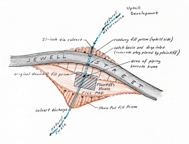
Figure 11
- In Marin vs. San Rafael,
a road fill (1942), culvert (1949), fill pad (1950), and home (1952) were
constructed upon and across a topographic swale
containing a natural
watercourse. The City’s cross-road culvert had been extended across the lot
to accommodate fill for the house pad with the City’s knowledge
in 1950. In 1975,
the homeowner (Marin) began to notice foundation soils collapsing over the
culvert extension during peak run-off events. The City denied
responsibility for
maintenance or repair, saying “as far as they are concerned, the pipe doesn’t
exist”. Marin then blocked the pipe with concrete, therein
causing a back-up
of run-off behind the roadway fill prism,
which flooded onto Jewell Street!
Marin prevailed in Court in an inverse condemnation
action against the
City under the doctrine of easement implied by usage.
The plaintiffs responded by placing
a "concrete obstruction" in and above the rupture to the pipe "in
order to prevent further damage to their property". The City then sought an injunction compelling
plaintiffs "to remove the concrete plug from this storm drain and to
restore the storm drainage system to a condition that is operational ....."
Although the court supported the
City's defense, the Appeal Court
reversed, ruling that the plaintiff's property had suffered physical damage
proximately caused by a public improvement or public use maintained as deliberately
planned and designed by the City. The
Appeal Court further
found that none of the plaintiff's damages were caused by their own act, or
fault, or negligence.
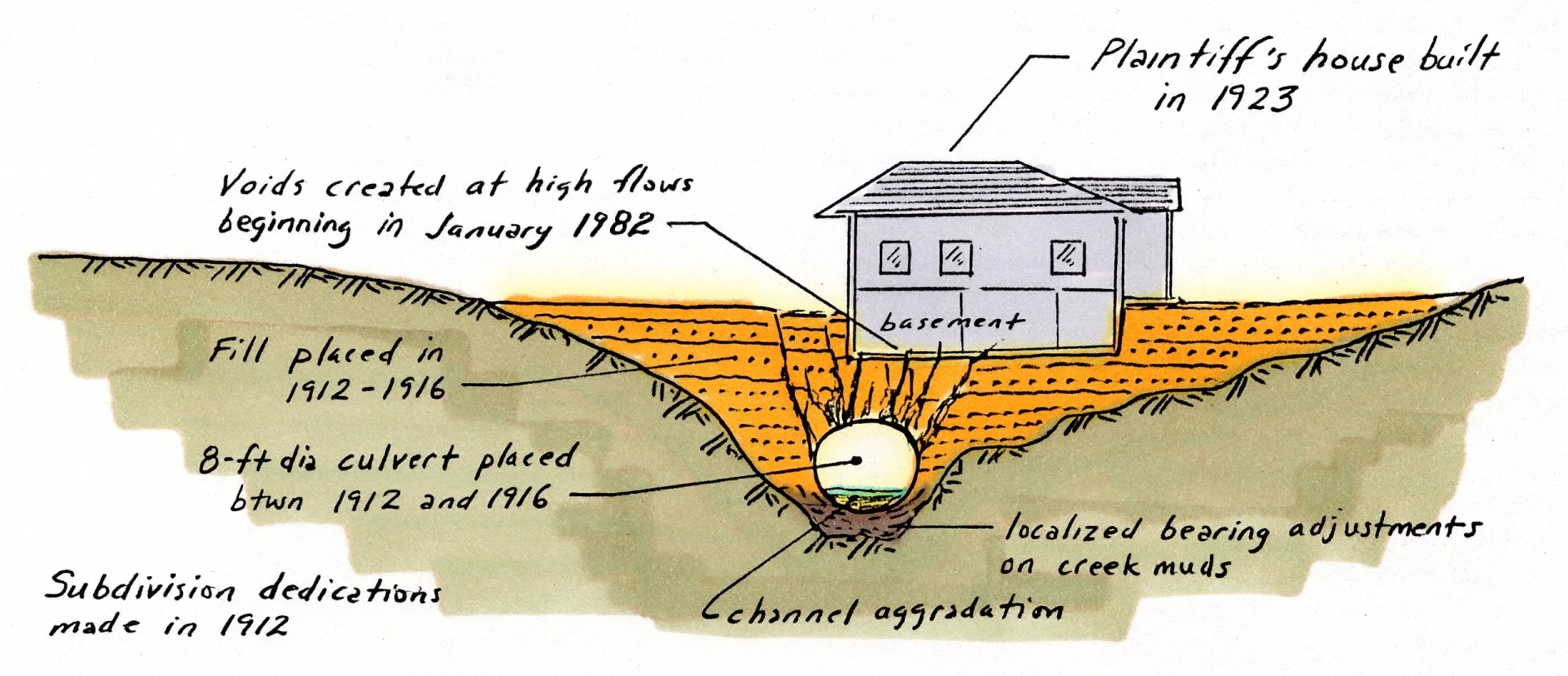
Chatman
vs Alameda County Flood Control District (1986) 183 CA 3d 424
A similar series of events were
tested in the case of Chatman vs Oakland
(1988) and Chatman vs Alameda County
Flood Control and Water Conservation District (1986) 183 Cal App 3d 424.
In this case, a hillside area was subdivided in east Oakland
between 1912 and 1916. At that time,
a culvert was placed across Lyon Creek and backfilled with fill to allow a
road crossing. The culvert was then extended and backfilled
to create a buildable lot which was subsequently developed in 1923. Chatman moved into the house in 1965 and began
to notice settlement beneath her home during a peak run‑off period in
January, 1982. An inspection of the
old culvert beneath her property revealed that it had become cracked and that
soil backfill was piping into the culvert during periods of high flow. The resulting soil cavities were then collapsing,
undermining the Chatman home (see Figure 12).
As in the case
of Marin, both the City and the local flood control district disputed responsibility
on the basis of ownership versus use. The culvert section beneath Chatman did not
lie within an accepted easement and the line was considered to be privately
owned, and therefore, privately maintained.
The Flood Control District eventually prevailed in their defense because
the plaintiff had allegedly implied dedication through annual inspections
begun by the District in 1963. The
Court held that, although the District knew of the dangerous condition of
the culvert through its inspections, it
could not be held liable for damage caused by the culvert unless it had owned,
controlled, constructed, repaired, or maintained the culvert. There was no discussion by the Court as to whether
the District had a responsibility to inform the affected property owners of the damaged culvert as soon
as the District learned of its condition.
However, in the remaining suit against the City of Oakland,
Chatman eventually prevailed (see Cal Jury Verdicts, V. 32, n. 32, Aug. 5, 1988). The Court ruled that the public benefited from
the culvert section within the Chatman property. After all, had Chatman blocked the culvert or
filled it in (as Marin did) grievous flood damage would have resulted to the
surrounding neighborhood. The City
had also exerted control in the
letting of building permits, allowing for the construction of a home over
the culvert. Oakland
countered by maintaining that the creek was not a natural watercourse, but
a man‑made channel constructed for the homeowners' benefit and convenience.
This would appear to have been an incompetent defense as Lyon Creek
is one of the earliest mapped landmarks in the East Bay, having formed the
land‑grant boundary between Ignacio and Antonio Maria Peralta in 1820
(one of the four original land grants in the San Francisco East Bay).
The Court ruled in favor of the plaintiff.
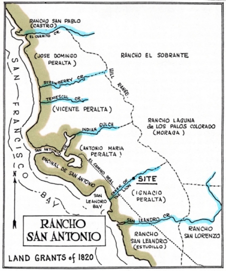
Figure 12
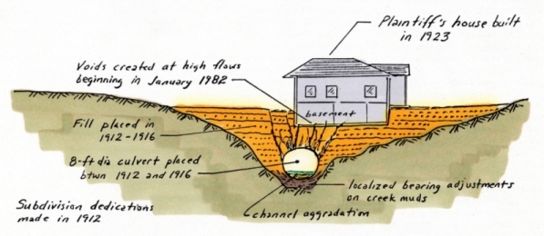
Figure13
- In the case of Chatman vs. Oakland
(1988), a plaintiff in the inverse condemnation action alleged implied dedication
of their own 8-foot-diameter
culvert on the basis
of its continual usage, benefiting the public welfare. Although the plaintiff
prevailed again the City, it lost and earlier inverse suit against
the
County Flood Control District on the basis of inspections being grounds for
inverse tort. The city’s assertion that Lyon Creek was not a natural watercourse
was unfounded based
upon early maps of the region (above).
BURDEN
OF PROOF OF "PUBLIC USE”
In many other cases, plaintiffs
have been less successful in alleging that there was sufficient public use
or benefit of improvements made on private property. In the case of Cantu vs PG&E (1987) 189 Cal
App 3d 160, plaintiffs purchased a lot in a 16‑unit subdivision with
private drives for access. Before any
of the lots were sold, PG&E had installed an 18‑inch‑wide,
6‑foot deep utility trench for gas, electricity, and telephone.
The plaintiff's property experienced
a landslide during the winter of 1980‑81 that their expert alleged was
due, in part, to the collection of water in the PG&E utility trench. Plaintiff sued PG&E under theories of inverse
condemnation, trespass, and nuisance. The
trial court found defendant inversely liable and rejected PG&E's defense
of comparative negligence. The jury
upheld PG&E's defense on the trespass and nuisance actions and returned
a verdict of no damages for plaintiff.
The court found that utility districts
have the legal right to:
a. Condemn lands to furnish utilities for customers; or
b. Operate and maintain lines along private
property without condemning property.
In the Cantu's case, PG&E
did not condemn the property nor did they condemn the land in an eminent
domain proceeding.
The Court concluded by stating
that "the law of inverse condemnation, viewed broadly and in perspective,
seeks to identify the extent to which otherwise uncompensated private losses
attributable to governmental activity should be socialized and distributed
over the taxpayers at large rather than borne by the injured individual"
(quoted from Val Alstyne, 1969.) The
court, after citing this language, held that the trench did not benefit the
public at large and that the running of line extensions to plaintiffs' residence
was not the type of quasi‑public activity where the risk of injury should
be spread over society.
CONCLUSIONS
Inverse condemnation proceedings
are supported in theory by individual rights of government compensation for
the taking or damaging of property. In
most instances, the public agency has caused unintentional physical damage
to property. Liability in inverse condemnation
for unintended physical damage is proper when the damage resulted from a public
entity's ownership, maintenance and/or use of a public improvement.
When a public agency fails to construct or maintain its improvement
properly, it takes a calculated risk that damage to private property may occur.
If damage to private property results, it is proper to require the
entity that took this risk to bear the loss when damage occurs.
The "Reasonable Use"
rule that has applied to surface waters since the Keys/Romley Case of 1966 was recently upheld in the California Supreme
Court decision in the Locklin case. As a consequence, the "Common Enemy Doctrine"
only affords protection insofar as the actions taken by someone to protect
their property can be deemed “reasonable”, as constructed and as maintained.
There is little question about
liability in the case of buried improvements, such as culverts or pipes ‑‑
whoever owns these is strictly liable for the damage they cause. However, recent decisions have served to extend
such liability to those sections of buried conduit that are privately owned,
but through which "public agency waters" may flow or be diverted
to. We can expect the area of "Implied
Dedication" suits to enlarge over the coming decade because private insurance
carriers have extensively modified their policies to exempt all manner and
form of flood or earth movement losses. If the damaged property is aged enough to be
beyond applicable statutes of limitations for patent or latent
defects, the public agency becomes the only entity with which to file suit.
According to many recent cases
in California, public entities may be liable under inverse condemnation for
any damages to property caused by a public improvement as deliberately designed
and constructed, regardless of any fault
or negligence by the Agency (see Olshansky, 1989, p. 110).
As the cost of litigation continues
its skyward acceleration in California
,
the burden will have to be spread back to the consumer via the embattled
agencies. Flood peril is the only nationally
adjudicated program which provides protection and relief from this type of
natural disaster. But, NFIP proceeds
only pay for a single occurrence of flooding, after this the parcel owner
must raise their floors to be above the 100-year or 500-year inundation levels.
No other systematic system of insurance exists to accommodate the
potentially prodigious losses that will be posed by massive
infrastructure aging/corrosion, earth movement, environmental pollution
(such as selenium), or earthquakes. Each of these could easily spawn losses in the
billions of dollars, the likes of which are probably not yet well appreciated
by decision makers.
REFERENCES
Bull, W.B., 1991,
Geomorphic Response to Climatic Change: Oxford
University Press, New
York, 326 p.
California Council of Civil Engineers and Land Surveyors,
1981, Drainage Law Syllabus, prepared by Turner and Sullivan, Sacramento,
Short Course Notes, 82 p.
Edwards, K. L., 1982, Failure of the San Jacinto River Levees
Near San Jacinto, California, From
the Floods of February 1980: in Storms, Floods and Debris Flows in Southern
California and Arizona in 1978 and 1980:
National Research
Council, National Academy Press, Washington, D.C., pp. 347-356.
McGuire, J.F., and Noziska, C.B., 1988, Landslide and Subsidence Liability
Supplement, March 1988; Calif Continuing Education of the Bar, Supplement
to California Practice Book No. 65, Berkeley, 182 p.
Morgan, A. E., 1952, The Miami Conservancy
District: McGraw-Hill Book Co., New York,
502 p.
Olshansky, R.B. and Rogers, J.D., 1987, Unstable Ground: Landslide
Policy in the United States:
Ecology Law Quarterly, V. 13, n. 4, pp. 939‑1006.
Olshansky, R.B., 1989, Landslide Hazard Reduction: A Need
for Greater Government Involvement: Zoning and Planning Law Report, V. 12,
n. 3 (March) pp. 105‑112.
Olshansky, R.B., and Rogers, J.D., 1992, The concept of reasonable
care on unstable hillsides: in Slosson, J.E., Keene, A.G., and Johnson, J.A.,
eds., Landslides/landslide Mitigation: Boulder, Colorado, Geological Society
of America
Reviews in Engineering Geology, v. IX, pp. 23-27.
Rogers, J.D., Pleistocene to Holocene
Transition in Contra Costa County, California: in Geology of San Ramon and
Environs, Northern California Geological Society Field Trip Guidebook, ed.
R. Crane, pp. 29-52.
Shuirman, G., and Slosson, J.E., 1993, Forensic Engineering:
Academic Press, San Diego, 256
p.
Sutter, J.H. and Hecht, M.L., 1974, Landslide and Subsidence
Liability: California Continuing
Education of the Bar California
Practice Book No. 65, Berkeley,
240 p.
Slossen, J.E., McArthur, R.C., and Shuirman, G., 1987, Legal
Misuse of Urban Hydrology Concepts and Regulations for Rural Areas; Engineering
and Hydrology Proceedings, Hydrology Division, Am. Soc. Civil
Engineers,
Williamsburg, VA, Aug. 3‑7, 1987, pp. 714‑719.
Sciandrone, J., Albrecht, T., Davidson, R., Douma, J., Hammer,
D., Hooppaw, C. and Robles, A., 1982, Levee Failures and Distress, San Jacinto
River and Bautista Creek Channel, Riverside County, Santa Ana River
Basin,
California: in Storms, Floods and Debris Flows in Southern California and
Arizona in 1978 and 1980: National Research Council, National Academy Press,
Washington, D.C., pp. 357-385
Van Alstyne, Arlo, 1969, Inverse Condemnation: Unintended
Physical Damage: Hastings Law
Journal, V. 20, n. 1 (January), pp. 431‑516.
V.T. Chow and N. Takase, 1977, Design Criteria for Hydrologic
Extremes: Journal of the Hydraulics Division, Am. Soc. Civil Eng’rs, v. 103,
n. HY4 (April), pp. 425-36.
presented at the San Francisco Insurance
Claims Forum in San Francisco, April
16, 1997
J. David Rogers is the Karl F. Hasselmann
Missouri
Chair in Geological Engineering
at the Missouri University of Science & Technology. He
received his B.S. in geology from the
California State Polytechnic University
in 1976, M.S. in civil engineering from U.C. Berkeley
(1979) and Ph.D. in geological and geotechnical engineering from U.C. Berkeley
in 1982. Between 1979-2001 he served
as a principal with three different geotechnical consulting firms and from
1994-2001 he served on the faculty of the Department of Civil & Environmental
Engineering at the University of California at Berkeley. His career has focused on natural disasters
associated with earth movement, floods and earthquakes. The author of over
100 articles, he is a recipient of the Rock Mechanics Award of the National
Research Council, the E.B. Burwell Award of the Geological Society of America
and the R.H. Jahns Distinguished Lecturer Award
of the Association of Engineering Geologists and Geological Society of America,
for his contributions to geoforensics,
with particular emphasis on the failure of dams and levees. He can be reached at rogersda@mst.edu
Questions or comments
on this page?
E-mail Dr. J David Rogers at rogersda@mst.edu.