_sm.jpg)
In 1978 Dave Rogers and Marvin Pyles, grad students at U.C. Berkeley,
began studying massive landslides in the Grand Canyon region.
They hired a private aircraft to take stereopair images of landslide
features throughout the canyon, sometimes from as low as a few hundred
feet! They noticed a buried channel of Tapeats Creek in the
Hakatai Shale in lower Tapeats Creek, shown above. Low level
flights over Grand Canyon are now prohibited to maintain peace and
quiet in the canyon.
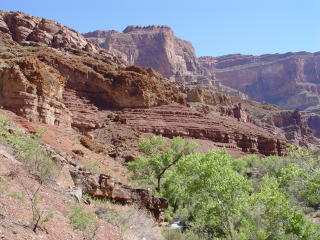
The same buried channel of Tapeats Creek is easily viewed on the western
side of Tapeats Creek from the hiking trails between Lower and Upper
Tapeats Campgrounds. Ancient landslide debris fills this older
channel and appears to have emanated from the older Surprise Valley
Landslide Complex above and to the west. The complex 3D nature
of this slide complex will require high tech mapping tools and techniques
to sort out the respective elevations and sequence of landslipage
events in shaping this portion of the Grand Canyon.
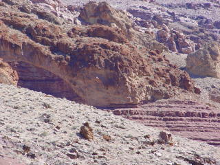
Close-up view of the old channel of Tapeats Creek clearly defined
in the Hakatai Shale, approximately 200 feet above the present channel.
The slide debris is cemented by travertine.
_sm.JPG)
The same proto channel can be traced for almost a kilometer along
the west side of lower Tapeats Creek. Notice that the rusty
colored travertine cement has held the slide debris together, allowing
it arch across a gap where the underlying Hakatai Shale has been removed.
Travertine is a form of calcium carbonate (CaCO3) usually deposited
in water. It is possible that these slides were activated in
conjuntion with some of the younger lava eruptions downstream, which
dammed the Colorado River.
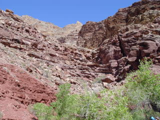
There are conflicting theories as to how the drainages in what is
now Surprise Valley evolved. Some theorize that Tapeats Creek
used to continue westward through Surprise Valley and flow into the
Colorado River near Deer Creek until divereted by massive landslides.
Others believe that a creek equivalent to modern day Bonita Creek
used to drain Surprise Valley into Tapeats Creek and was infilled
by the landsliding in Surprise Valley. Peter Huntoon believes
that Tapeats Creek used to flow southwesterly across what later became
Bonita Creek, joining the Colorado River below Cogswell Butte.
We hope to unravel these mysteries using laser range finders with
GPS receivers, to obtain prescise location and leveling data of key
geologic contacts.
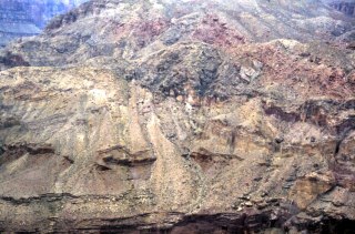
This image of landslide debris to the west of Tapeats Creek was taken
during the July 1978 flights over Grand Canyon. It shows a potential
buried channel outline with an axis leading into Surprise Valley.
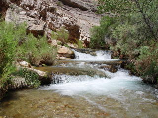
Tapeats Spring gushes an estimated 48 million gallons of water per
day (Huntoon 1970) and is the largest spring in the Grand Canyon.
Thunder River Spring is the second largest with an estimated discharge
of 21 million gallons per day. Negligable discharge emanates
from upper Tapeats watershed upstream of its confluence with the Tapeats
Spring branch. Several small springs in Crazy Jug and Saddle
Canyons provide somewhat fetid and mineralized water, containing epsom
salts.
_sm.JPG)
Smaller rotation slide blocks comprised of resistant Tapeats Sandstone
sit atop the Hakatai Shale along Tapeats Creek upstream of Thunder
River. Although small when compared to the slides flooring in
the Bright Angel Shale, these are interesting to note. These
are not classified as landslides on the most recent USGS geologic
map of the Grand Canyon, released in 2000.
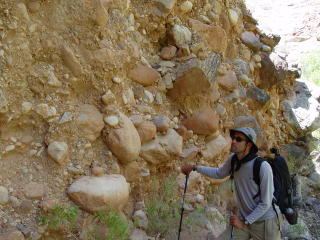
Debris flows play a dominant role in transporting sediment down tributaries
of the Grand Canyon and into the Colorado River. These mass
wasting events are one of the main forces acting to widen the Grand
Canyon. Debris flows are typified by angular and subangular
clasts that are matrix supported, as shown here. These materials are
pasted to the south side of Tapeats Canyon upstream of Thunder River.
Questions or comments
on this page?
E-mail Dr. J David Rogers at rogersda@umr.edu
or
Conor Watkins at cwatkin@umr.edu.
