MORAGA DEVELOPMENT CAPABILITY MAP AND GIS MAPS
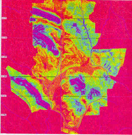
This project involved compilation of 36 different "layers" of geologic, environmental, geotechnical, hydrologic and planning data compiled on a spatial planform utilizing the Geographic Resources Analysis Support System (GRASS) developed by the Federal government (U.S. Army Engineers Construction Engineering Research Laboratory). 21 basic physical characteristics were compiled on separate maps, overlain on a City basemap compiled by the U.S. Geological Survey at a scale of 1:24,000. Five additional spatial parameters were then compiled as separate map "layers", in accordance with open space limitations that had recently been adopted by the Town of Moraga. After presentation of this data to the public, elected and appointed Town officials, six primary parameters were selected for consideration in limiting further development within the Town's jurisdiction. These parameters included: ridgelines, landslides, flood hazards, percent slope, vegetation and soil erosion potential. Landslide mapping involved identification of 23 different types of slides and the periods of occurrence, based on review of over 60 years of stereopair aerial imagery. The Town of Moraga encompasses approximately 56 square miles with a population of 35,000 in the of San Francisco East Bay Hills.
Client: Town of Moraga, Moraga, California 94556
Development Capabilities Map based on addition of six factors, all weighted equally: ridgelines, landslide susceptibility, flood hazard, percent slope, vegetation and soil erosion potential. To Second Page