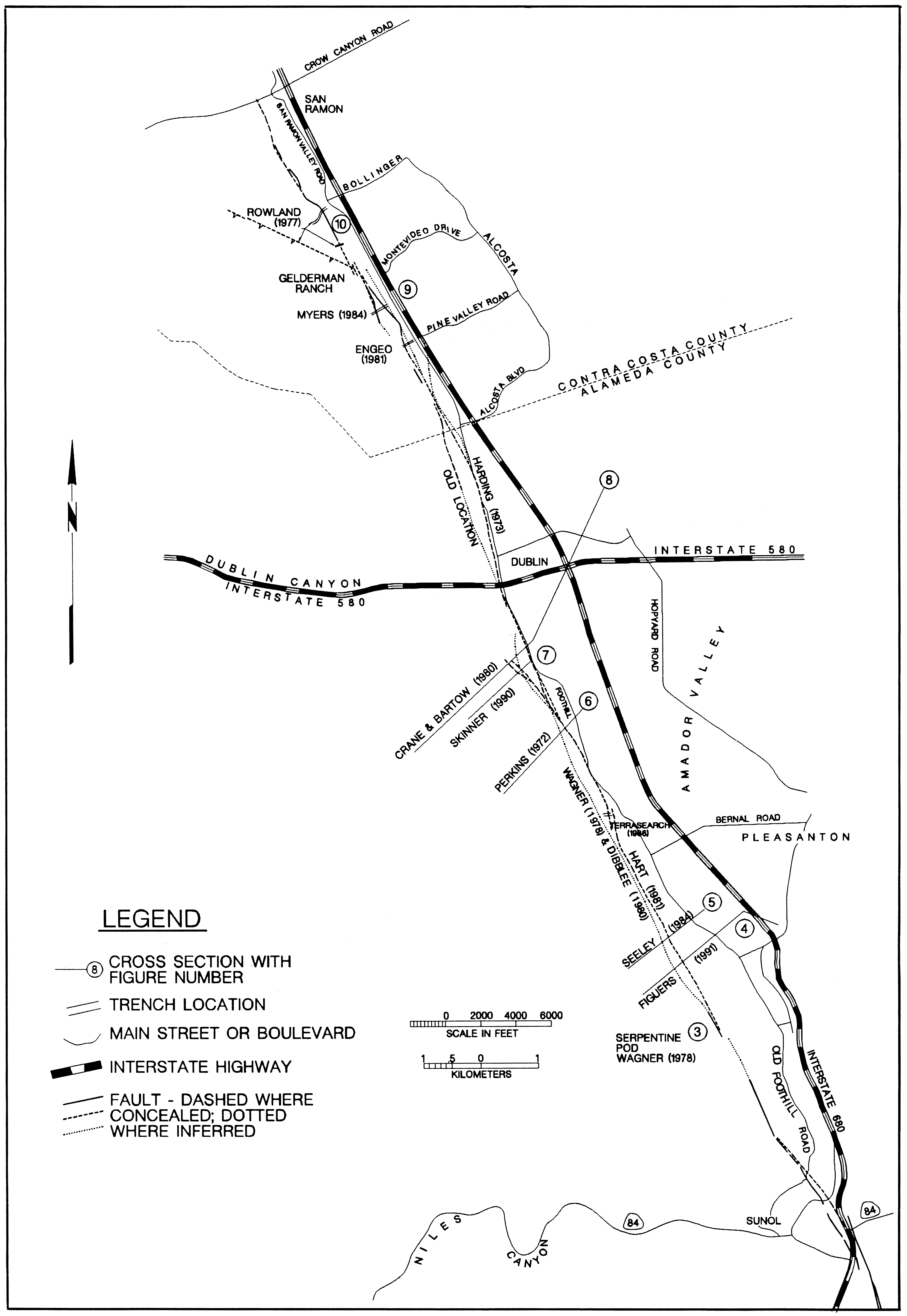
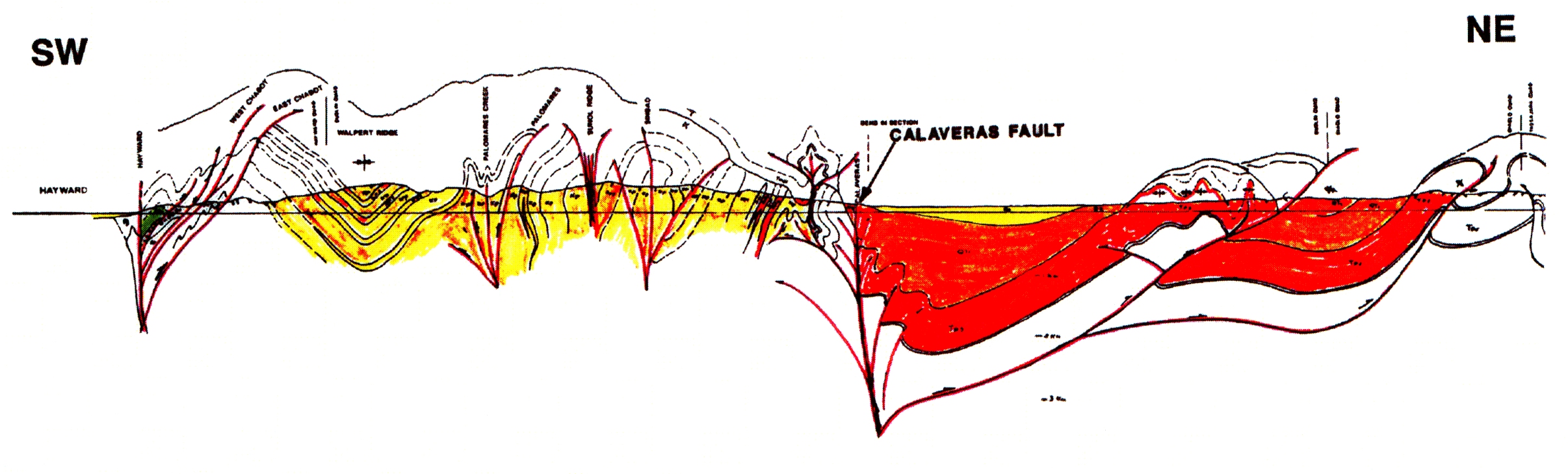
Figure 1. The Calaveras Fault from Sunol to San Ramon. The cross-section numbers are referred to in the text.
Tracking
the Elusive Calavaras Fault
from Sunol
to
San Ramon
J.
David Rogers and John M. Halliday
Introduction
The Calaveras fault system stretches 131 km, from south of Hollister, northward, into the Danville-Walnut Creek area (Taylor, 1992). Based on present creep rates, the fault can be divided into two overall segments; that south of the Calaveras Reservoir, and the San Ramon segment (Kelson, et al, 1992), between Sunol and Danville. The San Ramon segment (Figure 1) is the dominant structural feature of the Amador and San Ramon Valleys, forming their western boundaries and creating the structural barrier which comprises the Livermore Basin. This segment of the fault is typified by minor seismic activity and an apparently low slip rate. In much of the segment, its surface trace is uncertain because it appears to be buried beneath massive ancient landslides, earth/debris flow deposits and colluvium. Most researchers believe that strain accumulated along the Calaveras south of Calaveras Reservoir is transferred to the Hayward fault on the Mission Hills fault (Oppenheimer and Macgregor, 1991). Despite the apparent lessened activity on the northernmost trace of the Calaveras, it does appear to have spawned a Magnitude 6.9 earthquake on July 3, 1861, causing continuous ground rupture, 6-8 miles long, between the Amador Valley and Danville.
This article will summarize what is known about portions of the San Ramon segment of the Calaveras by briefly describing some of its distinguishing features reported at specific sites shown on Figure 1. This segment of the Calaveras fault zone consists of numerous linear, en echelon strands within a zone varying from tens of meters to over 500 meters wide. The segments appear to be vertical, but some strands dip noticeably, where they cut pre-existing thrusts. Page (1992) noted that thrusting is associated with the Calaveras fault at shallow depths.
Figure 1. The Calaveras Fault from Sunol to San Ramon. The cross-section
numbers are referred to in the text.
San Ramon Segment
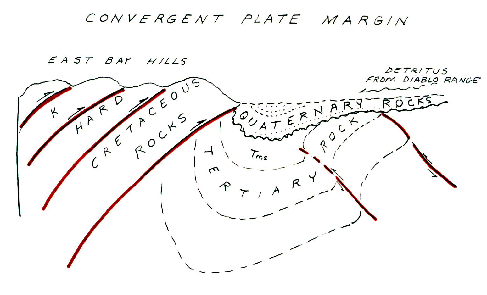
In considering the surface expression of the San Ramon segment we must be cognizant of the structural style which preceded the current strike-slip regime. Figure 2 presents sketches across the Calaveras near the Castlewood Country Club area of Pleasanton, as it likely appeared in early Quaternary time, when this portion of the California coastal borderland was within a convergent plate margin. As shown in the upper half of Figure 2, Cretaceous age units of the Great Valley sequence were repeatedly thrust, as the block between the proto Hayward and Calaveras faults underwent shortening. As the triple junction passed, the regional stress regime shifted to the current mode of a strike-slip motion. In so doing, it is likely that strike-slip faults initially utilized suitably oriented, pre-existing planes of weakness, such as the thrusts. Over time, the strike-slip faults gradually straightened and coalesced as the interplate slip increased. As shown in the lower half of Figure 2, what remains today is a composite mix of old and new structures, formed within different stress regimes.
![]()
B&W Version
Figure 2. Schematic cross-sections across the study area. The upper
cross-section indicates the structural relationships that
existed during thrusting in the early Quaternary. In this area, thrusting was
east vergent. The lower cross-section indicates
the structural relationships that exist today. The recent Calaveras strike-slip
fault has segmented the pre-existing thrust
panels, and re-activated suitably orientated thrusts. It is likely that the
overall location of the Calaveras fault was
controlled by pre-existing zones of weakness generated by the earlier thrusting.
Sunol-Castlewood Country Club - Immediately north of Sunol, the Calaveras fault is well defined at the base of Pleasanton Ridge, where it marks the boundary between the Great Valley sediments of the upper Monterey formation (Briones sandstone). This boundary can be difficult to identify as the change inattitude of the Panoche and Briones beds can be slight (Figure 3). Between Sunol and Castlewood Country Club, the best mapping and identification of the trace of the Calaveras was performed by Wagner in the early 1970's, but never published (Wagner, 1992). As shown in Figure 3, Wagner found a pod of serpentine separating the Panoche and Briones strata near an elevation of 800 feet on Pleasanton Ridge. The location of this pod is also shown as number 3 on Figure 1.
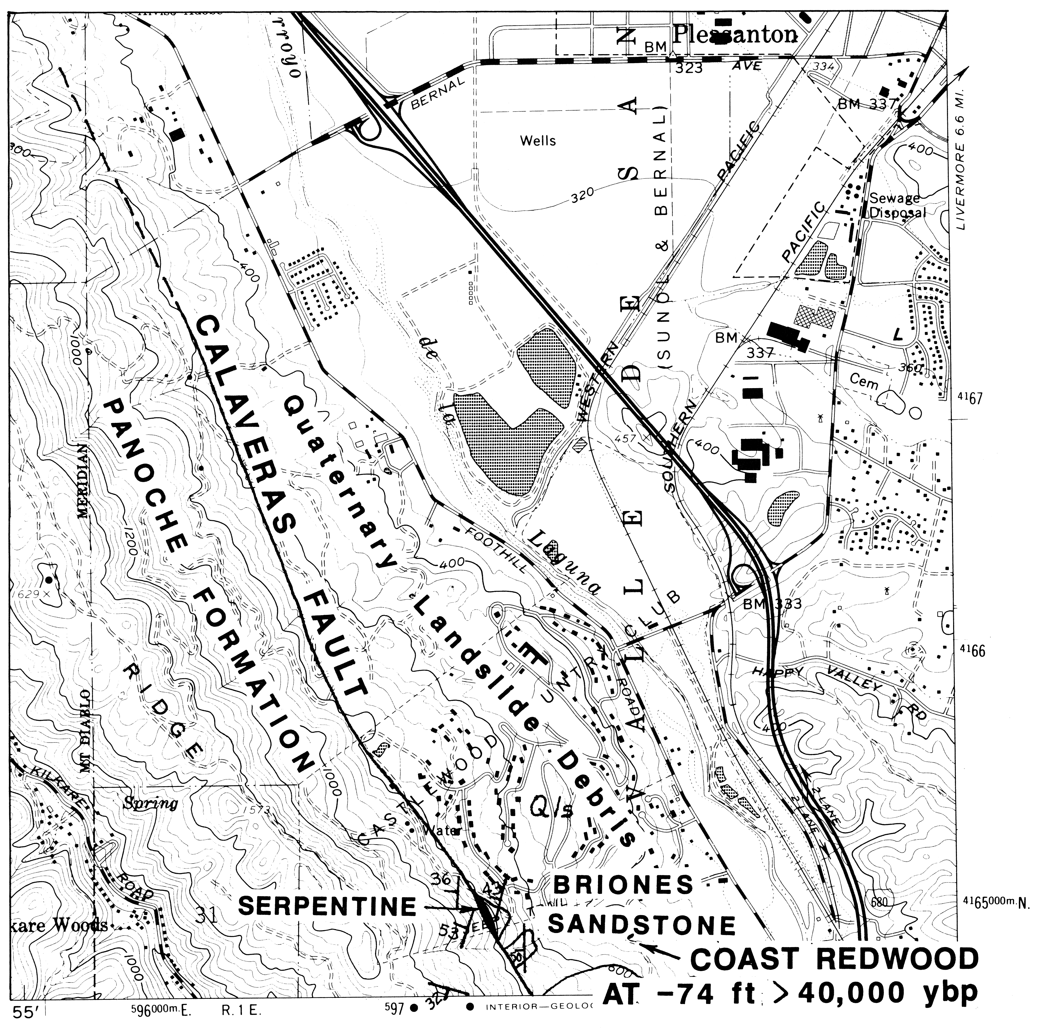
Figure 3. Details of the Sunol-Castlewood County Club segment of the
Calaveras fault (Wagner, 1978).
Note the location of the serpentine outcrop.
Castlewood Country Club was constructed on a massive mega-landslide complex, comprised of Great Valley Sequence rocks which slid off of Pleasanton Ridge in the late Pleistocene. This area has been one of controversy because the slide complex conceals the bedrock disconformity between the Cretaceous and Miocene strata. Figuers (1991) interpreted a 300 m deep water well for the Country Club, which was drilled in the narrow valley of the Arroyo de la Laguna, at the toe of the ancient slide complex (Number 4, Figure 1). He found approximately 107 m of Holocene and late Pleistocene gravel overlaying what appears to be steeply dipping Monterey formation shales (Figure 4).
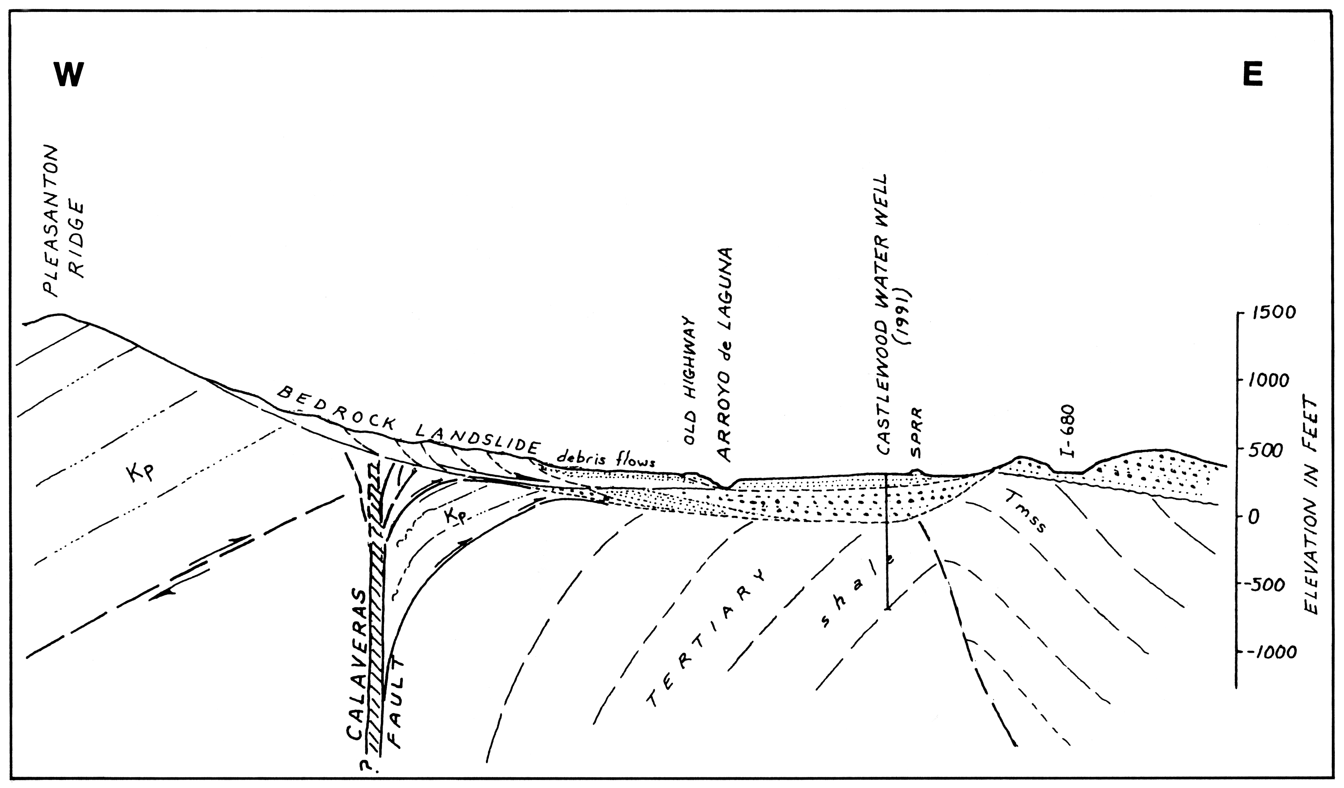
Figure 4. Cross-section through Castlewood County Club (number 4 on
Figure 1). No vertical exaggeration.
Johnson Ranch/Golden Eagle Farms - Just north of Castlewood, the Johnson Ranch/Golden Eagle Farms property has been the scene of numerous explorations in the 1980's. In 1984, Seeley and Perkins were among the first to utilize existing water well records (held by the Alameda County Zone 7 Water District) along the western margins of the Amador Valley.
These detailed logs helped provide limits on the eastern extent of the Calaveras. Seeley and Perkins (1984) utilized deep rotary borings to drill through the massive ancient landslide deposits blanketing the toe of Pleasanton Ridge (Number 5, Figure 1), in an attempt to locate the fault by identifying the relative locations of underlying Miocene and Cretaceous-age strata (Figure 5). This they were able to do with reasonable success, and their efforts remain the benchmark study of the fault location through this area. Subsequent workers (Applied Soil Mechanics, 1988) were unsuccessful in attempting to locate the fault with shallow trenching at the Golden Eagle Farms site. Most workers suspect the fault underlies the site because it would be kinematically impossible for a crustal sized feature to abruptly terminate without some type of fault termination features being present. None are known to exist in this area.

Figure 5. East-west cross-section through Golden Eagle Farms area (Sealy
and Perkins, 1984).
In 1972 Perkins completed a study of the Western Outlier of the Great Valley Sequence in the hills between the Hayward and Calaveras faults, including Pleasanton Ridge. He constructed a cross section (Number 6, Figure 1) three km north of Golden Eagle Farms, a portion of which is shown in Figure 6. Perkins mapped the fault as two distinct strands, the easternmost he held to be the main trace.
Moller Ranch - One and a half km north, on the Moller Ranch (Number 7, Figure 1), the Calaveras makes a westerly bend. Here, Skinner (1990) identified several traces of the fault. The easternmost zone is the active trace. Similar to Perkins (1972) findings, it consisted of tilted Quaternary-age gravels lying within a narrow zone between two strands of the fault. At the extreme northeastern portion of the Moller Ranch, Skinner (1990) again identified the eastern strand of the Calaveras fault, but did not show it displacing the youngest soil horizons. The western trace appears older and quiescent, containing a plug of serpentine, some 6 m wide (Figure 7). This was an important finding because it documents that serpentine can be found adjacent to inactive strands of the fault.
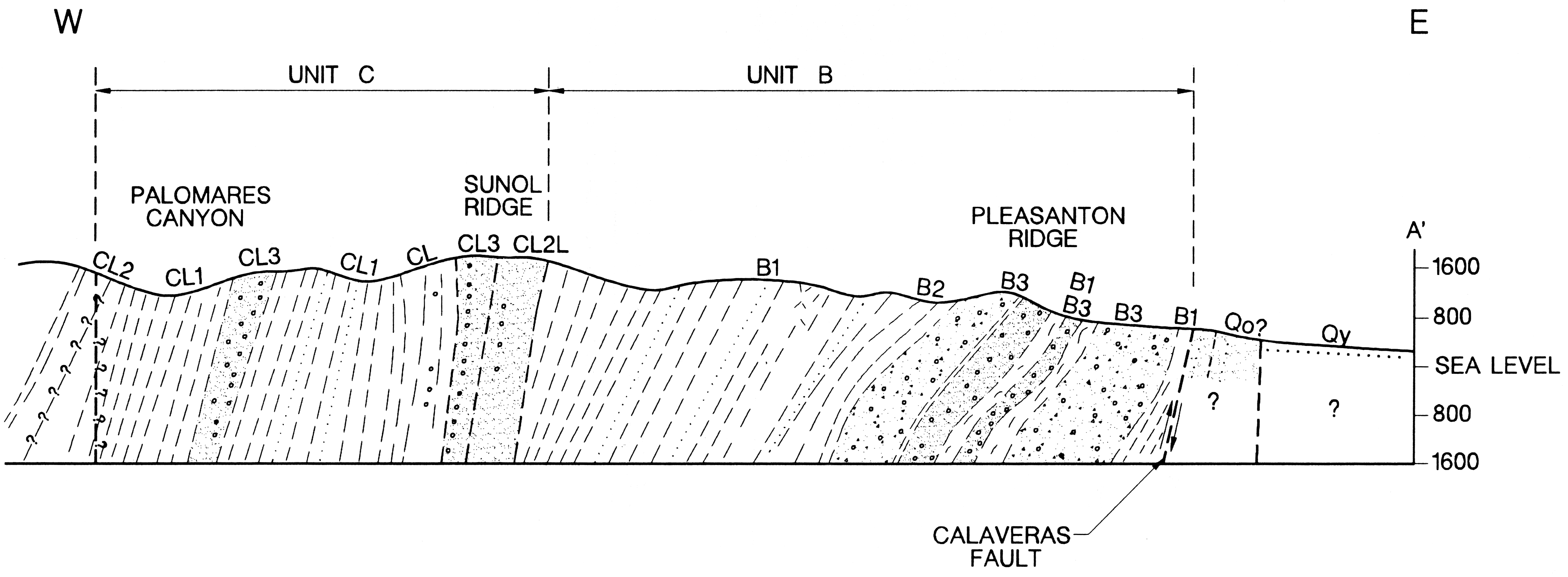
Figure 6. The eastern portion of Perkins (1972) cross-section through
the Golden Eagle Farms area.
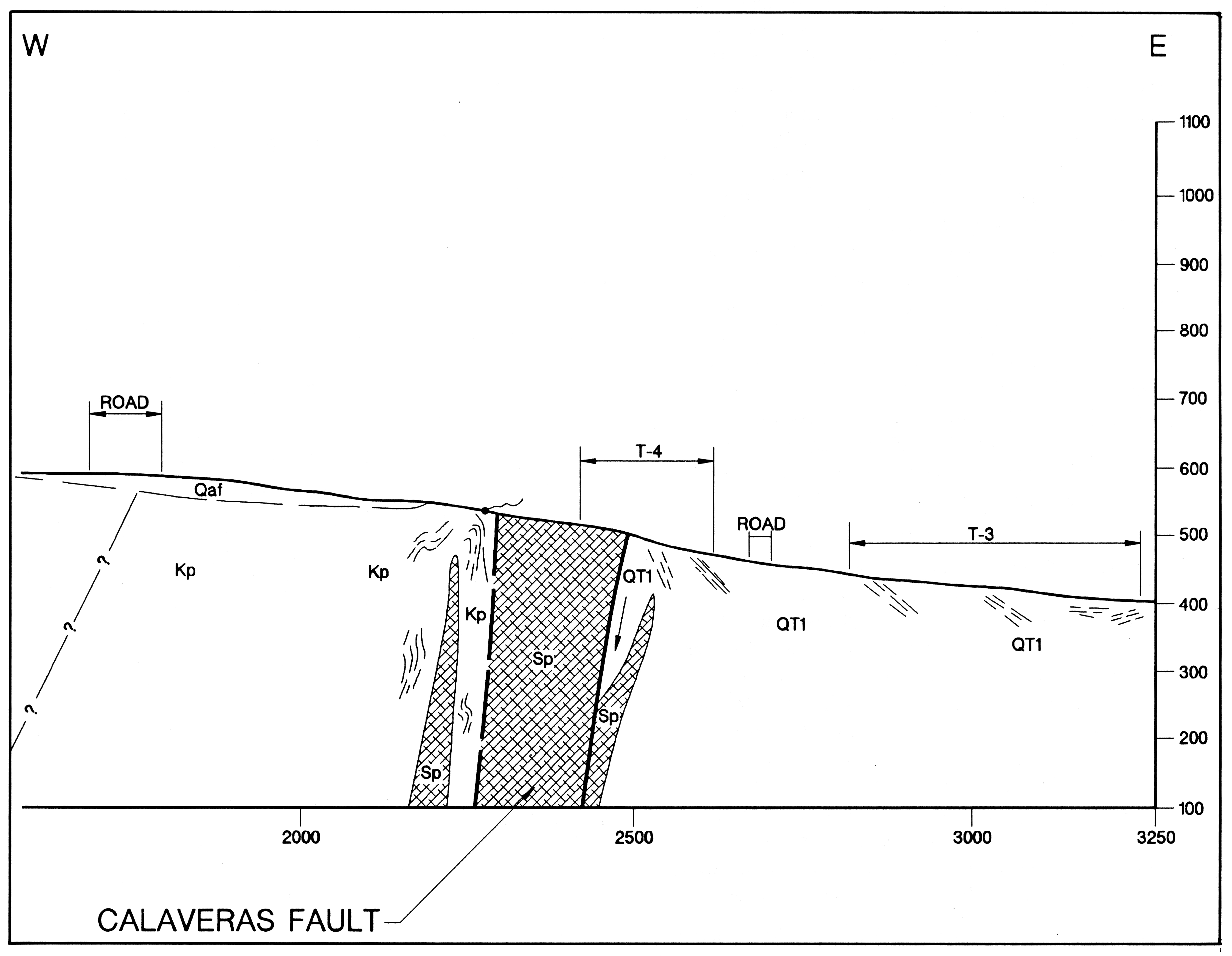
Figure 7. The western, inactive trace of the Calaveras fault on Moller
Ranch (Skinner, 1990). Note plug of serpentine in the fault zone.
In 1988, Crane and Bartow produced the first regional, semi-balanced cross section through the area. A portion of this section is reproduced as Figure 8. This section shows the thrust splays emanating from the main trace of the fault. What is important to appreciate is that, in many instances, the parallel, ancillary thrust features are more prominent than the main trace of the fault. In 1973, Harding was among the first to study the Calaveras in Dublin, north of Interstate 580. His trenches suggested that the active trace of the fault was located some 300 m east of the supposed trace, as shown in Figure 1. These findings were subsequently incorporated into the State's mapping work by Hart (1981),although Wagner (1978), Dibblee (1980), and Crane (1988) all show the major offset in the older position (Figure 1). In this area, the Calaveras may simply be a wide zone, although most agree that the main trace lies buried, to the east of Miocene age strata exposed west of the western terminus of Alcosta Boulevard, as Harding (1973) originally suggested.
B&W Version

Figure 8. A portion of Crane and Bartow (1988) regional cross-section
across the study area. No vertical exaggeration.
Further north, between Dublin and San Ramon, the Calaveras has been studied at various times over the past two decades for a series of small developments (Engeo, 1981, Figure 1). Best among these studies was by Darwin Myers Associates (1984) at the Venterra Property, next to the Gelderman Ranch, where Montevideo Drive intersects San Ramon Valley Boulevard (Number 9 on Figure 1). In this area, Myers (1984) found both the main trace of the fault and a left step-over segment, separated by a pressure ridge (Figure 9). Myers shows the two segments joining up with one another a short distance north, on the Gelderman parcel, which was subsequently studied by Engeo in 1990.
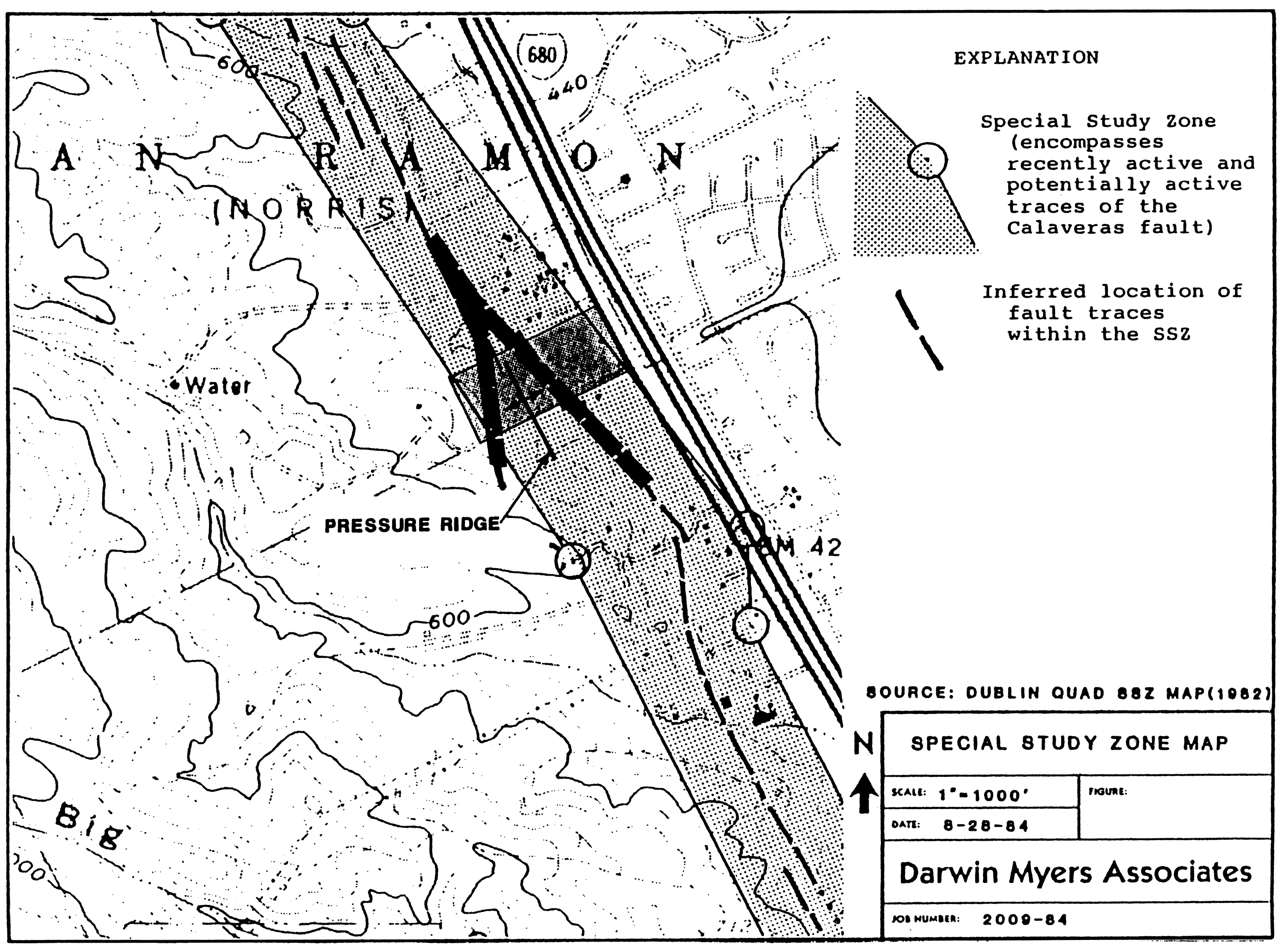
Figure 9. Active splays of the Calaveras Fault (Myers, 1984) near San
Ramon. (See Figure 1, number 9 for overall location)
. Instead of being a single strand, the Calaveras consists of two active traces
separated by a pressure ridge.
In the San Ramon area, the fault is typified by a series of parallel offsets and stepovers, with scant reliable information as to which of the breaks is the "active" trace, which is presumed to have broken the ground surface in 1861. In the late 1970;s, Rowland (1977, 1979) undertook a particularly interesting study of the fault in south San Ramon for the Twin Creeks portion of the old Bishop Ranch (Number 10, Figure 1). In the second study (Rowland, 1979),a large trench was excavated with scrappers, down to a depth of 20 feet. Within this "megatrench", the main trace of the Calaveras was tentatively identified, near the toe of the natural slope.
CONCLUSIONS
Much remains to be revealed about the true character and extent of the San Ramon segment of the Calaveras fault. Approximately two-thirds of its supposed surface trace is obscured by ancient landslides and other surficial deposits. In addition, the fault zone itself is extremely complex, containing a multitude of splays, step-overs, and other structural discontinuities. Despite reports of what must have been a M. 5.6-6.9 earthquake on July 3, 1861 (see companion article, this volume), no correlatable surface trace of sufficient consistency has been identified to date. In fact, with the exception of the area south of Castlewood and that in Dublin, the fault yields little insight as to which of its many traces are the most active. Surface creep features, common on the Hayward, Rodgers Creek and Concord faults, seems absent along the San Ramon segment of the Calaveras. Nevertheless, given its structural position, we can expect strong energy propagation and release along the segment when the more pregnant segments just to the south rupture. When such events occur, it is likely that we will experience the strongest ground shaking of the I-680 corridor to date, and we will, in all likelihood, learn much more about the Calaveras.
This manuscript was reviewed by C. L. Taylor and S. H. Figuers.

Aerial oblique view looking northwest, up the Calaveras fault,
with Castlewood Country Club in foreground.
REFERENCES
Applied Soil Mechanics, 1988, Geologic and Seismic Hazards Evaluation, Golden Eagle Farm, Pleasanton, California: consultant's report to Currin Construction Co.: 74 p., 6 figures, 3 appendices.
Berlogar Geotechnical Consultants, 1990, Geotechnical Investigation Laurel Creek, Foothill Road, Pleasanton, California, for Presley of Northern California: consultant's report (AP-2523): 37 p., 119 plates.
Crane, Ron, and Bartow, G.W., 1988, Structure Section D-D' to accompany Field Trip Guidebook: The Geology off San Ramon Valley and Environs-April 30, 1988: Northern California Geological Society, San Ramon.
Engeo, Inc., 1981, Alquist Priolo Exploration, San Ramon Valley Methodist Church, San Ramon, California: consultant's report (AP-1437) by Engeo, Inc., Concord: 13 p., 4 figures.
Figuers, Sands H., 1991, Castlewood Country Club deep water well geologic consultations: Consultant's report by Rogers/Pacific, Inc., Pleasant Hill: 3 p.
Harding, Richard C., 1973, Calaveras fault relocated near Dublin: Earth Science Associates Newsletter, Palo Alto.
Kelson, K.I., Lettis, W.R., and Simpson, G.D., 1992, Progress Report on Paleoseismic Investigations at Leyden Creek, Northern Calaveras fault zone: Proceedings, this conference.
Myers, W. Darwin, 1984, Fault Investigation, Venterra Property, City of San Ramon: Consultant's report by Darwin Myers Associates, Pleasant Hill: 24 p., 8 figures, 5 plates, 1 appendix.
Oppenheimer, D.H. and Macgregor-Scott, N., 1992, The Seismotectonics of the East San Francisco Bay Region: Proceedings, this conference.
Page, B.M., 1992, Tectonic Setting of the San Francisco Bay Region: Proceedings, this conference.
Perkins, Michael E., 1972, Geology and Petrology of the East Bay Outlier of the Great Valley Sequence, Alameda County, California: University of California, Berkeley: Master's thesis: Department of Geology, 120 p.
Rowland, Richard, 1977, Geologic Investigation on A Portion of the Bishop Ranch south of Bollinger Canyon Road and west of San Ramon Boulevard, San Ramon, California: consultant's report (AP-690) by Terrasearch, Inc., San Jose: 19 p., 30 figures, 2 appendices.
Rowland, Richard, 1988, Soil and Geologic Investigation, Castleridge Development, Foothill Road, Pleasanton, California: consultant's report (AP-2248) by Terrasearch, Inc.,Dublin: 46 p., 32 figures, 3 appendices.
Seeley, Marc W., and Perkins, M.E., 1984, Preliminary Evaluation of Geologic Impacts on Land Development Capability, 310 acre Walter Johnson Foundation property, Pleasanton, California: consultant's report by Merril, Seeley, Mullin, Sandefur, Inc., Pleasanton: 55 p., 5 appendices.
Skinner, Ray P., 1990, Report on Geologic Investigation Moller Property, Foothill Boulevard, Pleasanton, California: consultant's report (A-2988) by Berlogar Geotechnical Consultants, Pleasanton: 18 p., 24 plates, 1 appendix.
Taylor, Charles L., 1992, Historical Perspective on the Location of the Calaveras Fault: this proceedings.
Wagner, J. Ross, 1978, Late Cenozoic History of the Coast Ranges East of San Francisco Bay: University of California, Berkeley: Ph.D. dissertation, Department of Geology and Geophysics, 161 p.
Questions or comments on this page?
E-mail Dr. J David Rogers at rogersda@umr.edu.
![]()