Thunder River Spring has been ranked as one of the top ten backpacking
destinations in North America by Backpacker Magazine. This scenic
spring is a true desert oasis and provides an excellent resting spot
from the heat and sun of Surprise Valley. Although the casual
backpacker may not notice, a complex landslide exists adjacent to
the spring and anyone hiking to or from Surprise Valley must traverse
this slide to reach Thunder River's breathtaking outlet.

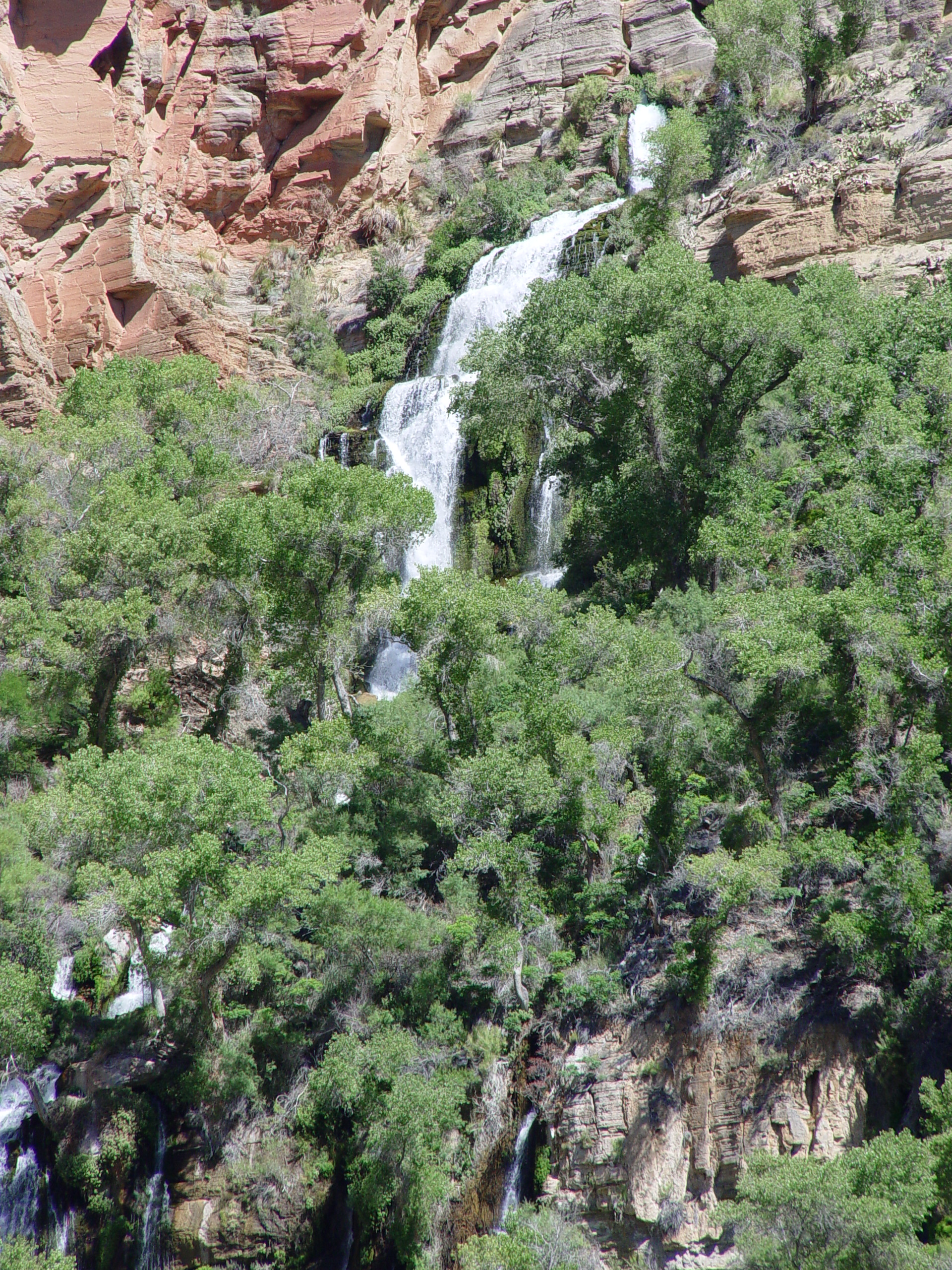
Thunder River Spring emerges from the desert cliffs as a spectacular
set of waterfalls that cascade 1/2 mile down a steep side canyon to
Tapeats Creek. Thunder River's estimated discharge of 21 million
gallons per day (over 240 gallons/second) ranks number 2 for springs
on the north side of the Grand Canyon behind Tapeats Spring.
Tapeats Spring gushes forth with 48 million gallons per day.
As with Tapeats Spring, Thunder River is structurally controlled
by a fault and supplied by a partially waterfilled cave. It
likely played a controlling role in triggering the massive Thunder
River Landslide, which forms the southwestern side of Thunder River
Gorge. The failure initiated in the Bright Angel Shale and progressed
up through the Muav, Redwall and Supai Formations, displacing nearly
2000 feet of stratum. The slide is on the eastern margin of
Surprise Valley and likely related to the large scale landslippage
that typifies this portion of the Grand Canyon.
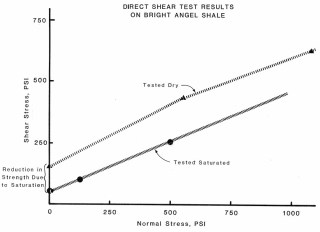
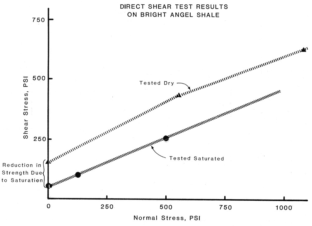
In
1979 Rogers and Pyles undertook a field maping and sampling program
of the slide's basal rupture surface, followed by an extensive laboratory
testing program. Trimmed specimens of the Bright Angel Shale
were tested in simple shear, under dry and saturated conditions.
Saturation was achieved by placing trimmed specimens in a consolidometer
for 6 months under back-pressure and evaluating the pore ressure coefficients.
Normal pressures ranged between 0 and 1100 psi, simulating up to 1,200
feet of rock overburden. The tests revealed a 2/3 drop in cohesion
upon saturation. This significant loss of shear strength could
occur if the Bright Angel Shale was inundated by the rising waters
of reservoirs caught behind lava or landslide dams downstream.
If inundation were the triggering mechanism, the age of the Thunder
River Slide may be something on the order of 750,000 years before
present (750 Ka), when the highest lava dams were emplaced near Toroweap
(Lava Falls).
The
strength parameters were input into limit equilibrium slope stability
analysis of the Thunder River Landslide to see if its genesis could
be explained. The deepest slides could only fail if entrapped
pore water pressures were included in the model. The combination
of these two discoveries leads one to believe that Thunder River Spring
played an important role in the formation of the Thunder River Landslide.
The Thunder River Slide is located immediately west of Thunder River
and failed just above the Boxcar Member of the Bright Angel Shale,
a trait common to many of the large landslides in the Grand Canyon.
Thunder River has since incised a channel through the slide margin,
exposing the basal rupture surface and adjacent stratigraphy.
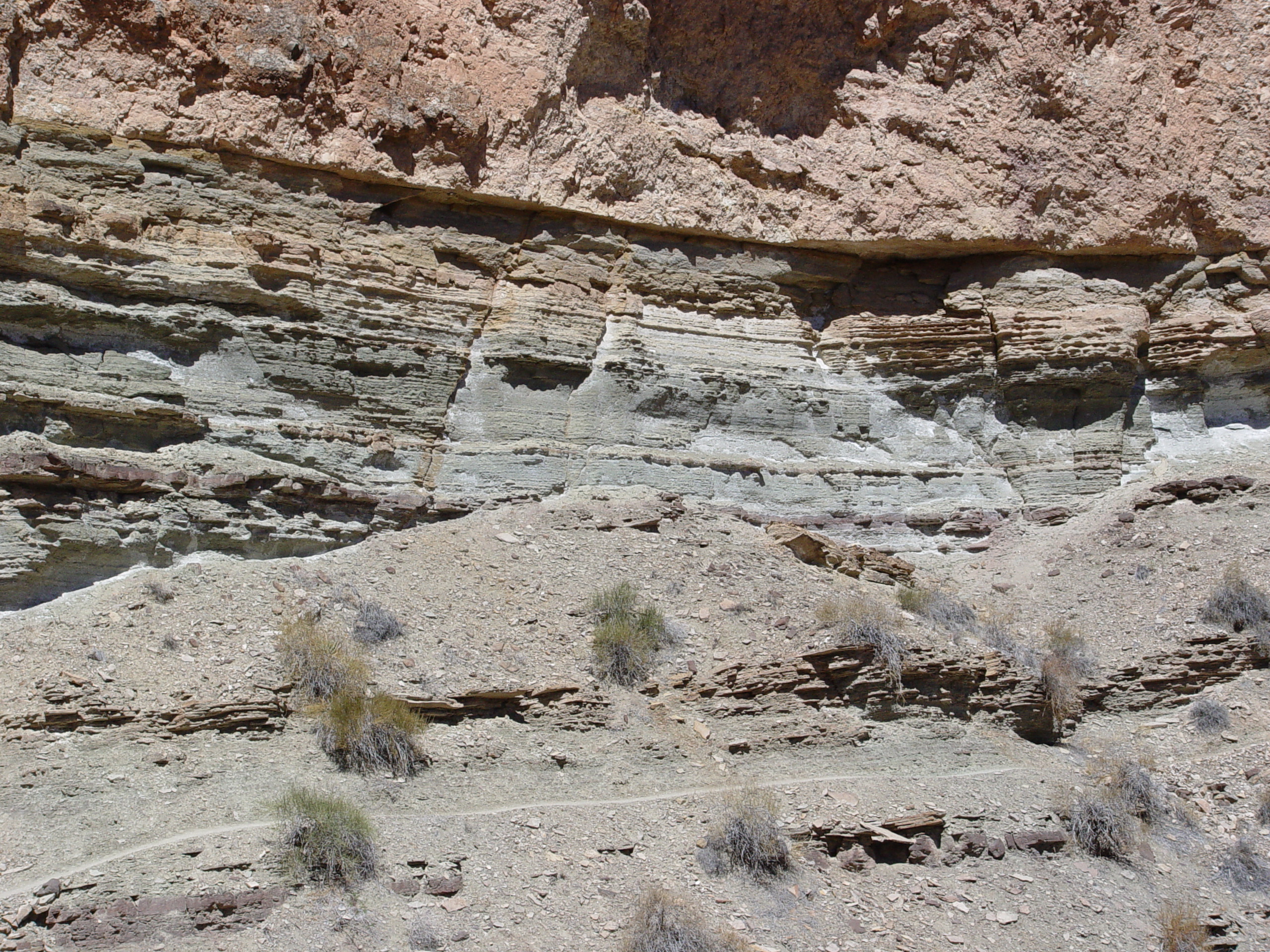
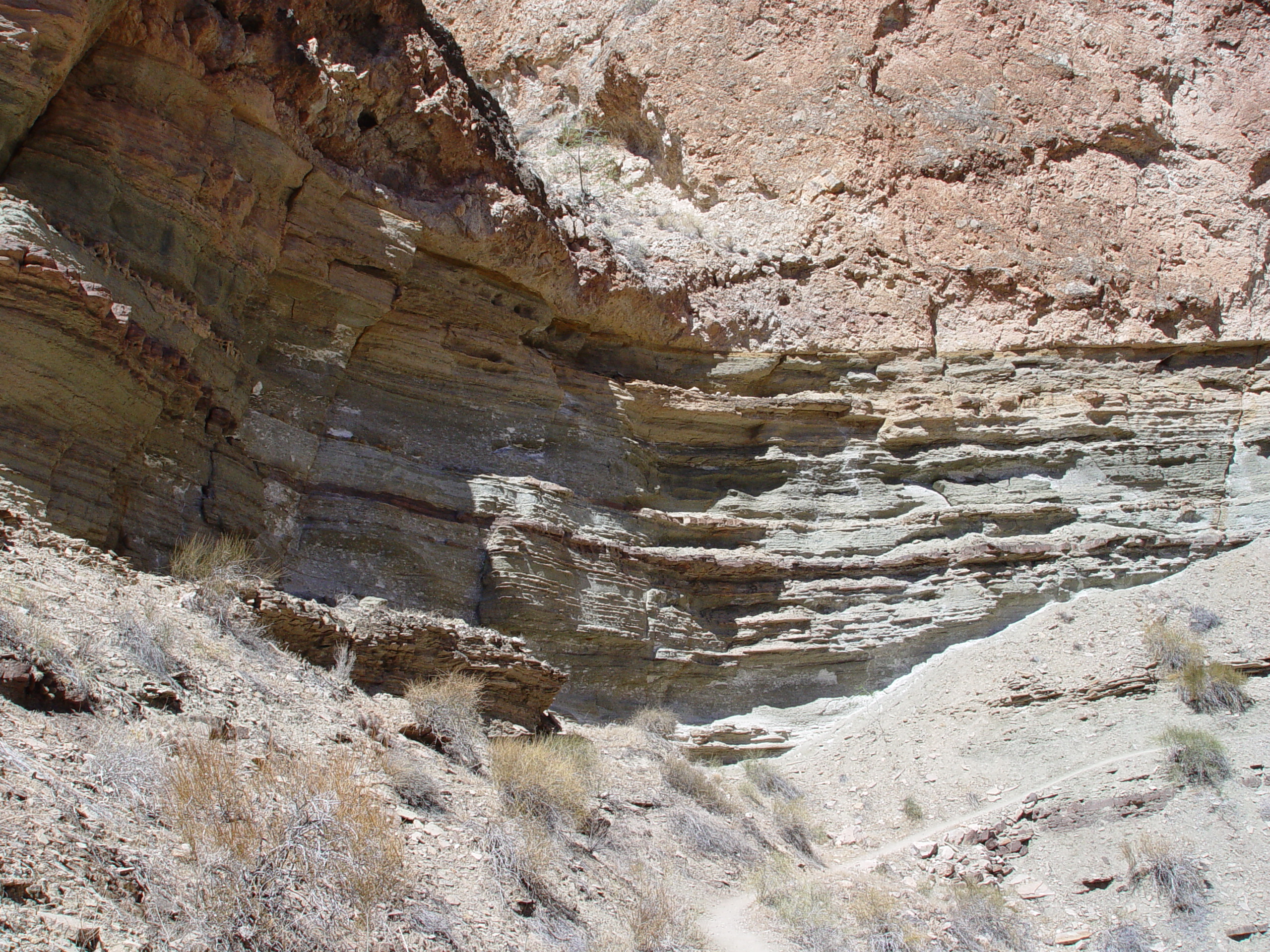
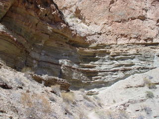
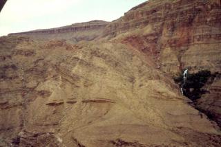
A line running just above halfway on the left side of this photo is
the slide plane. The rusty colored upper Boxcar Member may be
seen near the bottom of the photo.
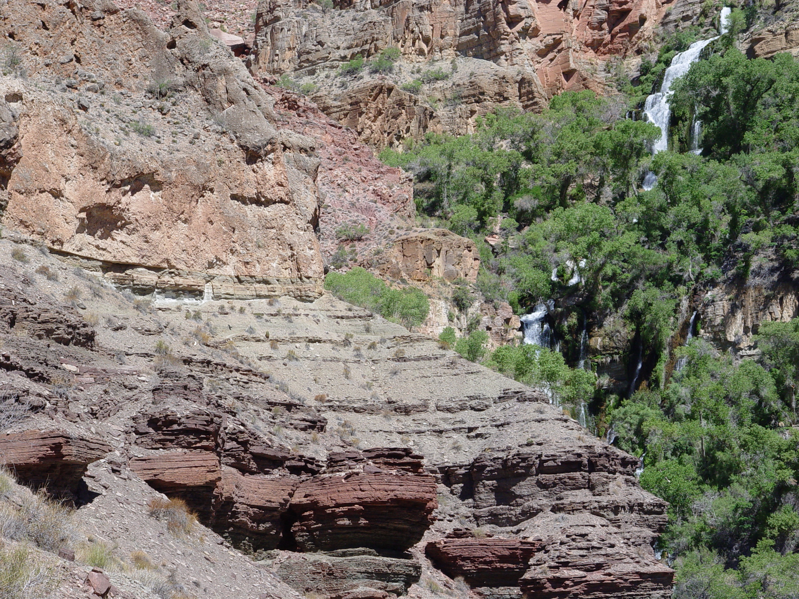
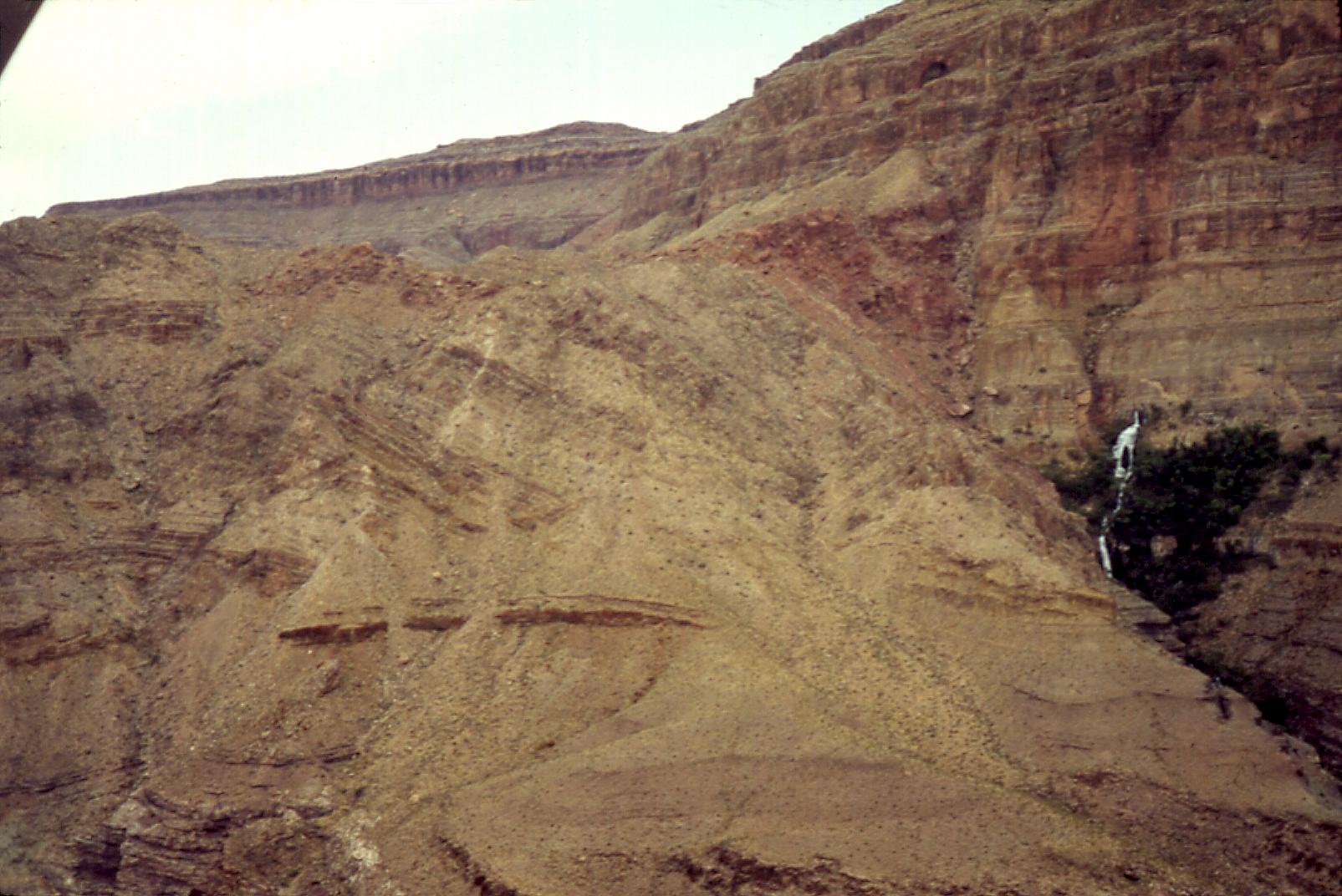
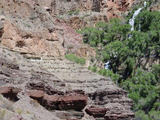
This photo shows the trail leading to Thunder River from Tapeats Creek.
The landslide is clearly visible in the upper portion of the photo.
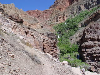
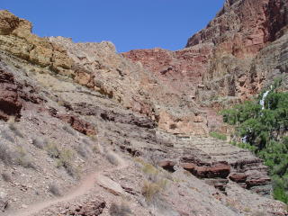
The failure surface of the Thunder River Slide has been exposed by
the incision of Thunder River. The trail between Thunder River
and Tapeats Creek follows this contact for a while, providing an exceptional
view of the buried slide plane.
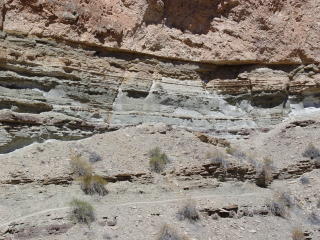
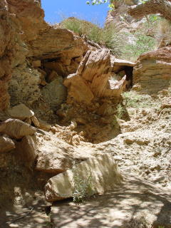
Another view of the basal slide plane. A graphic zone of travertine
cemented landslide breccia overlies a greenish gray fissile bed of
the micaceous Bright Angel Shale.
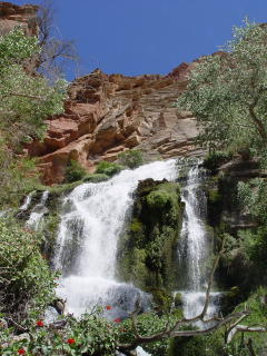
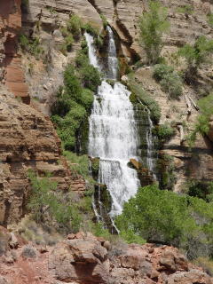
Thunder River Spring is a true desert oasis and is one of the most
photographed features in the Grand Canyon. The rushing water
cools the surrounding area, providing welcome relief from the stagnant
heat of Surprise Valley, which can reach 120 degrees in the summer.
Wildflowers, hummingbirds, and lush vegetation flourish here but are
surrounded by a hot, dry desert environment.
Bedrock slide debris extends all the way to the margins of Thunder
River Spring, supporting the hypothesis that the landslide is related
to the spring. Perhaps the outlet to Thunder River was once
choked with slide debris much as Tapeats Spring is today. It
is likely that the slide once covered the spring outlet.
Thunder River emerges from two large cave outlets and numerous smaller
seeps.
The four figures below were created by J. David Rogers and
Marvin Pyles for use in
EVIDENCE
OF CATASTROHPIC EROSIONAL EVENTS IN THE
GRAND CANYON OF THE COLORADO RIVER, ARIZONA,
a
paper written for the Second Conference On Scientific Research In
The National Parks, 26-30 November 1979, San Francisco, California
These
figures illustrate our hypothesis as to how the landslide adjacent
to Thunder River formed.
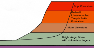
Initial assumed condition of the Thunder River Landslide for our back-analyses.
This condition occurred when the Tapeats Creek and the proto-Surprise
Valley stream had excavated to an elevation of just under 3000 feet,
through the Boxcar Member of the Cambrian age Bright Angel Shale.
The failure mass was just under 2000 feet high!
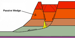
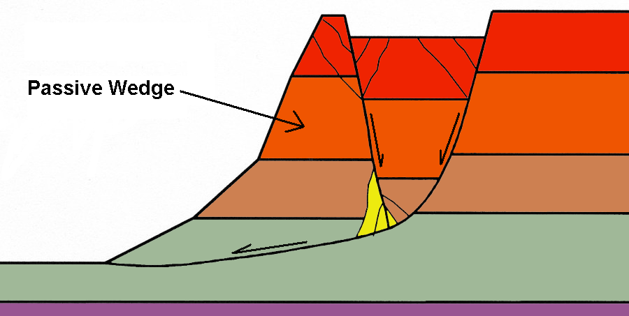
The landslide initiated as a composite wedge failure, with one wedge
sliding horizontally and the other dropping vertically, as depicted
here.
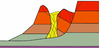
As the passive
wedge continued to translate towards Tapeats Canyon, a brecciated
zone developed between the back-rotating block and the passive wedge.
Sliding of a passive toe wedge on a weak bedding plane, brecciation
of a middle zone and back rotation of the heel of the slide mass,
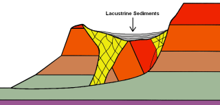
all appear to have occurred concurrently. After failure, the
large headscarp graben formed a closed depression that was filled
with lacustrine sediments and then breached by the headward erosion
of Bonita Creek. This is how the Thunder River Landslide appears
today. In 1979 we called it a “block glide with rotated
graben”. Using current nomenclature this would be termed
a “composite landslide”, because it exhibited two or more
styles of movement simultaneously.
This aerial oblique view of the Thunder River Landslide taken in July
1978 shows the backrotated graben and the horizontally bedded
block glide above Thunder River. The size of this slide makes
it hard to entirely comprehend from the ground.
Questions or comments
on this page?
E-mail Dr. J David Rogers at rogersda@umr.edu
or
Conor Watkins at cwatkin@umr.edu.