Next: Data Previous: Introduction

![]()
![]()
Next: Data
Previous: Introduction
Background of the experiment
In the middle of March, 1994, a set of PASSCAL instruments arrived at UCLA, which were originally intended for use by USGS and SCEC to record seismic waves from shots detonated by the Navy in Santa Monica bay. The experiment was postponed until October, 1994 because of environmental concerns. We took advantage of the availability of the instruments to study differential damage caused by the Northridge earthquake. A plan for deployment was made quickly. An announcement was published on Daily Bruin, UCLA's student newspaper, that asked for volunteers to allow installation of a seismometer in their backyards. Responses were so abundant that some applicants had to be turned down. Because it was term time and most of the field team members were students, almost all of the deployment and disk changing jobs were done during weekends. The project was named the Northridge Earthquake Aftershock Recording (NEAR). The acronym was appropriate since this experiment is near UCLA, in contrast with others that we have been working on, such as those in Baikal-Mongolia, East Africa, and on Mars, which are far from UCLA. Limited funding was provided for the field work. The hard work of the volunteers is appreciated.
Field setup
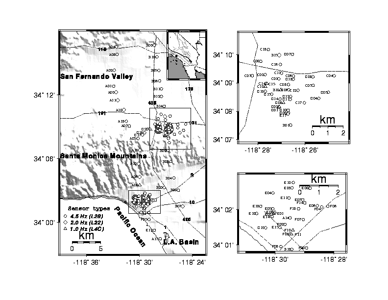
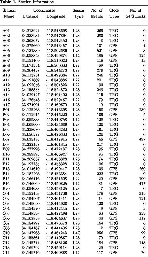
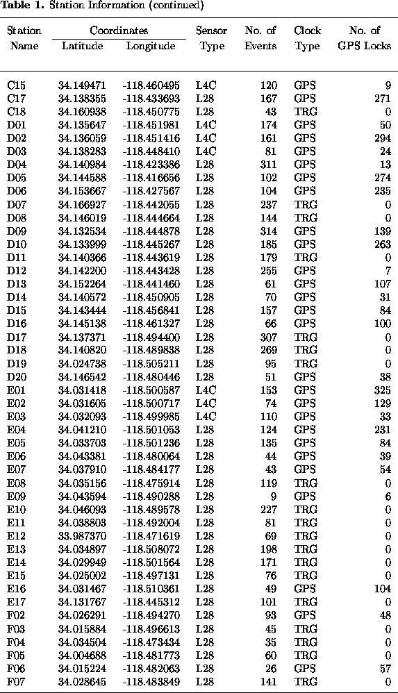
The 98 stations were located in two clusters and along two profiles
(Figure 2 and Table 1(a);(b);(c)). The distance between stations in the
two clusters is about 1 km and that for the profile stations is
about 2 km.
The western profile had twenty stations, and the eastern one,
sixteen stations. Both profiles were about 35 km long, along
lines with strike 165 ![]() , and traversed the San Fernando valley,
Santa Monica Mountains, and the northwestern part of the Los Angeles
Basin. The northern cluster of 36 stations was centered in Sherman Oaks
in a 7 km by 7 km area; the distance and azimuth of the center of the
Sherman Oaks cluster (station B16) from the epicenter are about 11 km,
, and traversed the San Fernando valley,
Santa Monica Mountains, and the northwestern part of the Los Angeles
Basin. The northern cluster of 36 stations was centered in Sherman Oaks
in a 7 km by 7 km area; the distance and azimuth of the center of the
Sherman Oaks cluster (station B16) from the epicenter are about 11 km,
![]() . The southern cluster of 29 stations was
centered in Santa Monica in a 4 km by 3 km area;
the distance and azimuth of this cluster (station F10)
from the epicenter are about 21 km,
. The southern cluster of 29 stations was
centered in Santa Monica in a 4 km by 3 km area;
the distance and azimuth of this cluster (station F10)
from the epicenter are about 21 km, ![]() (Figure 2).
(Figure 2).
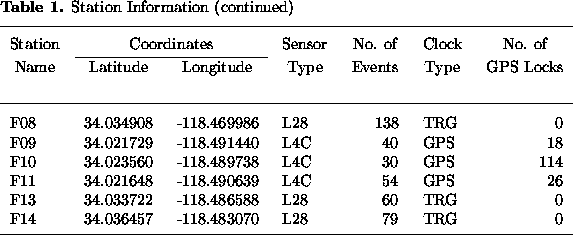
A trigger-mode was used to record relatively strong events. The length of each seismogram was 80 s, which includes 20 s of pre-triggering time. The long pre-triggering time proved to be useful because the S-waves from some events were the triggering signals at some stations, and the long pre-triggering time saved the first P wave arrival. The sampling rate was set at 125 samples per second. The triggering rate and quality of the data depend on the magnitudes and other parameters of the events, as well as ground noise, which in the cities is directly related to local time. The triggering parameters differed from station to station in rorder to minimize `false' triggering, which was mostly caused by passing vehicles. The Reftek recorder computes the running ratio of the short-time average (STA) and long-time average (LTA) of a selected seismometer component, and an event is declared when the ratio exceeds a programmed threshold, which is called the trigger ratio. Initially, we used the triggering parameters, LTA window = 15 seconds, STA window = 0.2 seconds, Trigger Ratio=8.0 for most of the stations. After the first week, the parameters were adjusted for some of the stations based on their performance. For stations in populated valleys and basins, a lower trigger ratio of 3.0 to 5.0 and shorter STA window of 0.1 to 0.15 s was found to be more effective in discriminating signals in regions of high ground noise. In contrast, for stations on bedrock, a high trigger ratio of 10.0 to 15.0 and small LTA window 5.0 to 10.0 s were effective in reducing vehicle triggers. The numbers of events recorded by the stations are shown in Table 1(a);(b);(c)).
About half of the stations were equipped with GPS receivers and thus had relatively accurate times and locations (Table 1(a);(b);(c))). The clocks of stations without GPS receivers were corrected every week during station service using external GPS clocks, and the locations for those stations were obtained from USGS 1:24,000 series topographic maps. We note that the GPS signal in the cities is much weaker compared to open areas due to the blockage of buildings. As a result, about 1/4 of the stations with GPS receivers locked on the satellite timing and location signals less than once a day on the average. As a further result, large uncertainties in the timing and station locations were introduced in some of the data. Clock types and number of locks for stations with GPS receivers are shown in Table 1(a);(b);(c)).
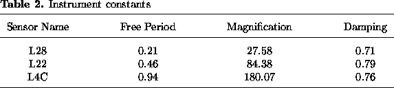
Seventy-five stations were equipped with L28 4.5 Hz sensors, eight with L22 2.0 Hz sensors and fifteen with L4C 1 Hz sensors (Table 1(a);(b);(c))). The amplification, free period, and damping factor are shown in Table 2, obtained by using the average of the calibration test results provided by Aaron Martin at UCSB. Please note that the waveforms submitted to the SCEC and IRIS data centers have not been corrected for instrument response, because we believe it can be done by users easily according to personal preference. Sensor types are listed in Table 1 and shown in Figure 2.
Except for station A17, all of the stations were equipped with either 72A-06 or 72A-07 Reftek junior DAS's (Data Aquisition System). The serial numbers of the DAS for the 06's and 07's start with '6' and '7', respectively. The only station (A17) that used another type of Reftek DAS did not record any useful data. The DAS numbers and DAS locations are shown in Table 3.
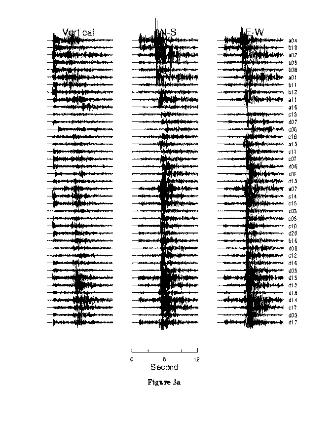
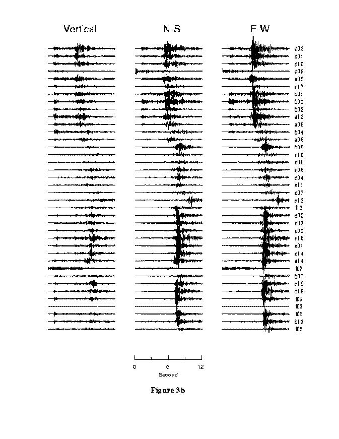
Seismograms from one of the best events are shown in Figure 3a;b.
Participating Personnel
M. Benthien, J. Boyce, J. Davis, M. Davis, P. Davis, S. Gao, L. Green, D. Guo, P. Jögi, S. Lee, H. Liu, J. Murphy, J. Norris, G. Pei, P. Slack, L. Sung, and M. Winter, were actively participants in the installation and operation of the stations.
